Figure 1. Location of the Oak Ridge Reservation
ORR Background
In 1942, the federal government established the Oak Ridge Reservation (ORR) in Anderson and Roane Counties in Tennessee as part of the Manhattan Project to research, develop, and produce special radioactive materials for nuclear weapons. Four facilities were built at that time. The Y-12 plant, the K-25 site, and the S-50 site were created to enrich uranium. The X-10 site was created to demonstrate processes for producing and separating plutonium. Since the end of World War II, the role of the ORR (Y-12 plant, K-25 site, and X-10 site) has broadened widely to include a variety of nuclear research and production projects vital to national security.
Over the years, ORR operations have generated a variety of radioactive and nonradioactive wastes. A portion of these remain in old waste sites, and some pollutants have been released into the environment. Consequently, in 1989, the ORR was added to the U.S. Environmental Protection Agency's (EPA's) National Priorities List (NPL). Under a Federal Facility Agreement (FFA) with EPA and the Tennessee Department of Environment and Conservation (TDEC), the U.S. Department of Energy (DOE) is conducting cleanup activities at the ORR. These agencies are working together to investigate and to take remedial action on hazardous wastes generated from both past and present site activities.
ATSDR's Involvement and Other Health Activities at ORR
The Agency for Toxic Substances and Disease Registry (ATSDR), one of several agencies within the U.S. Department of Health and Human Services (HHS), is the principal federal public health agency charged with evaluating human health effects of exposure to hazardous substances in the environment. ATSDR, a sister agency to the Centers for Disease Control and Prevention (CDC), has for many years worked closely with the CDC's National Center for Environmental Health (NCEH). In December 2003, ATSDR and NCEH—both charged with controlling and preventing diseases related to environmental causes—consolidated their administrative and management functions and are now known as NCEH/ATSDR. For more information on these and other affiliated agencies, please refer to http://www.atsdr.cdc.gov/ and http://www.cdc.gov/.
Since 1991 ATSDR has responded to requests and addressed health concerns of community members, civic organizations, and other government agencies in the affected areas of the ORR by working extensively to determine whether levels of environmental contamination in off-site areas present a public health hazard, that is, a source of potential harm to human health as a result of past, current, or future exposures. During this time, ATSDR has identified and evaluated several public health issues and has worked closely with many parties. While the Tennessee Department of Health (TDOH) conducted the Oak Ridge Health Studies to evaluate whether off-site populations have been exposed in the past, ATSDR's activities focused on current public health issues related to Superfund cleanup activities at the site. Prior to this public health assessment, ATSDR addressed current public health issues related to off-site areas, including the East Fork Poplar Creek area and the Watts Bar Reservoir area. The agency's Oak Ridge Reservation Web site at http://www.atsdr.cdc.gov/HAC/oakridge/ contains additional information on ATSDR's ORR-related public health activities.
During Phase I and Phase II of the Oak Ridge Health Studies, the TDOH conducted extensive reviews and screening analyses of the available information and identified four hazardous substances related to past ORR operations that could have been responsible for adverse health effects: radioactive iodine, mercury, polychlorinated biphenyls (PCBs), and radionuclides from White Oak Creek. In addition to the dose reconstruction studies on these four substances, the TDOH conducted additional screening analyses for releases of uranium, radionuclides, and several other toxic substances.
To expand on TDOH efforts—but not duplicate them—ATSDR scientists conducted a review and a screening analysis of the department's Phase I and Phase II screening-level evaluation of past exposure (1944–1990) to identify contaminants of concern for further evaluation. Using this review, ATSDR scientists are conducting public health assessments on X-10 iodine 131 releases, Y-12 mercury releases, K-25 uranium and fluoride releases, PCB releases from X-10, Y-12, and K-25, and other topics such as the Toxic Substances Control Act (TSCA) incinerator and off-site groundwater. In spring 2004 ATSDR completed a public health assessment on Y-12 uranium releases and in this public health assessment evaluates radionuclides released from White Oak Creek. In conducting these public health assessments, ATSDR scientists are evaluating and analyzing the data and findings from previous studies and investigations to assess the public health implications of past, current, and future exposures.
ATSDR's Evaluation of Exposure to Radionuclide Releases From X-10
As stated, this public health assessment evaluates the releases of radionuclides to the Clinch River (and the Lower Watts Bar Reservoir, or LWBR) from the ORR via White Oak Creek, assesses past, current, and future exposure to radionuclide releases for people who use or live along the Clinch River (and within the White Oak Creek study area; that is, the area along the Clinch River from the Melton Hill Dam to the Watts Bar Dam), and addresses the community health concerns and issues associated with the radionuclide releases from White Oak Creek. This document does not address the release of other contaminants of concern such as mercury, radioactive iodine, PCBs, uranium from the K-25 facility, and fluorides, nor does it address exposures to those contaminants. ATSDR will evaluate these contaminants and other topics in separate public health assessments. Please note that this document only evaluates off-site exposures to White Oak Creek radionuclide releases for downstream residents and others who use or who live along these waterways. It does not evaluate any exposures potentially occurring on site at the reservation, including exposures to workers and other individuals who may contact contaminants while at the ORR.
Most of the radioactive contamination in White Oak Creek came from ORR's X-10 facility (formerly Clinton Laboratories and now known as the Oak Ridge National Laboratory [ORNL]). The entire ORNL site encompasses approximately 26,580 acres. The main operations at the laboratory take place on about 4,250 acres—the original X-10 site. The ORNL site is located in two valleys: Bethel Valley and Melton Valley. In 1943, the X-10 site was built as a "pilot plant" to demonstrate plutonium production and separation. The government had planned to run the X-10 site for 1 year, but this time frame was made indefinite as operations at the facility were broadened. Over time, operations at X-10 grew to include nuclear fission product separation, nuclear reactor safety and development, and radionuclide production for worldwide use in the medical, industrial, and research fields. Today, the ORNL site is globally recognized as a research and development laboratory.
White Oak Creek travels south along the X-10 border, flows through or past several contaminated sources in Melton Valley (e.g., solid waste storage areas), and ultimately empties into White Oak Lake. The government had anticipated using this man-made lake as a "settling basin" for radionuclides released from the X-10 site. Some of the contaminants, however, did not settle in White Oak Lake. Instead, they flowed over White Oak Dam into the White Oak Creek Embayment, and then entered the Clinch River. As contaminants in White Oak Creek surface water enter the Clinch River, their concentrations will dilute; and when the Clinch River meets the Tennessee River, the concentrations will dilute even further. The ORR-related surface water and sediment that traveled through the Clinch River eventually flowed into the LWBR. The LWBR, which is located downstream of the ORR, extends from the confluence of the Clinch River and the Tennessee River to the Watts Bar Dam. Between 1944 and 1991, approximately 200,000 curies of radioactive waste were discharged from X-10 into the Clinch River via White Oak Creek.
ATSDR concluded that past, current, and future exposures to radionuclides released from White Oak Creek to the Clinch River/Lower Watts Bar Reservoir are not a public health hazard.
People who used or lived along the Clinch River or Lower Watts Bar Reservoir in the past, or who currently do so or will in the future, might have or might yet come in contact with X-10 radionuclides that entered the Clinch River or Lower Watts Bar Reservoir via White Oak Creek. However, ATSDR's evaluation of data and exposure situations for users of these waterways indicates that the levels of radionuclides in the sediment, surface water, and biota are—and have been in the past—too low to cause observable health effects.
Past Exposure (1944–1991)
ATSDR evaluated past exposure to radionuclides released into the Clinch River from the X-10 site via White Oak Creek. ATSDR's evaluation showed that the estimated external and internal radiation doses were not expected to cause harmful health effects. Therefore, ATSDR concluded that past off-site exposure to those radionuclides traveling from X-10 to the Clinch River via White Oak Creek was not a public health hazard.
To evaluate past exposure to radionuclide releases from the X-10 site via White Oak Creek, ATSDR primarily relied on data generated during Task 4 of the TDOH's Reports of the Oak Ridge Dose Reconstruction, Radionuclide Releases to the Clinch River from White Oak Creek on the Oak Ridge Reservation—an Assessment of Historical Quantities Released, Off-Site Radiation Doses, and Health Risks (referred to as the "Task 4 report"). The Task 4 team conducted a screening process that allowed the team to estimate the dose and subsequent risk (to individuals and to target organs) associated with exposure to 24 radionuclides in Clinch River sediment, surface water, and biota. The team assumed that individuals would have been exposed between 1944 and 1991—a period of up to 48 years—and that exposure to radionuclides would have occurred during recreational activities or from the consumption of water, milk, fish, local meats, or local crops. The Task 4 team used conservative screening parameters with the intention of calculating estimates of risk that are not likely to underestimate the actual risk to any exposed individual. Meaning, for each radionuclide and exposure pathway evaluated, the Task 4 team expected these calculated estimates to overestimate the risk for most or all real individuals.
Through its screening process, the Task 4 team concluded that 16 out of 24 radionuclides released from White Oak Creek to the Clinch River did not need further evaluation because the estimated screening indices, (i.e., the calculated probabilities of developing cancer), were below the minimal level of concern. The Task 4 team further studied the following radionuclides: cobalt 60 (Co 60), strontium 90 (Sr 90), niobium 95 (Nb 95), ruthenium 106 (Ru 106), zirconium 95 (Zr 95), iodine 131 (I 131), cesium (Cs 137), and cerium 144 (Ce 144). In addition, the team eliminated the following pathways from further analysis:
The pathways requiring additional evaluation included drinking water, fish consumption, external radiation from contaminants in shoreline sediments, and ingestion of milk and meat from cattle that grazed near the river.
For this public health assessment, ATSDR used the Task 4 report results to re-evaluate past radionuclide exposures. ATSDR also used the report to estimate doses to community members who consumed local livestock or milk, or who used the Clinch River downstream from the mouth of White Oak Creek for recreation or for drinking water. These estimated doses for past radionuclide exposures to community members varied by critical organ, by pathway of exposure, and by gender.
ATSDR's evaluation indicated that people who ate fish taken from that part of the Clinch River near Jones Island received the highest estimated doses of radiation. Doses from fish consumption exceeded dose estimates for all exposure pathways by at least a factor of 6. Primarily, the dose depended on how often people ate fish and on the area of the Clinch River where the fish were collected. The highest cumulative organ doses (1944–1991) were for individuals who consumed fish frequently (1 to 2.5 fish meals per week) and caught their fish near Jones Island, close to the mouth of White Oak Creek. For people consuming fish from the Jones Island area of the Clinch River, estimated organ doses were higher than doses received by people who walked along the shore or who ingested water, milk, meat, and fish at locations downstream of Jones Island.
The Task 4 authors predicted that from any of the exposure pathways, human bone surface received the highest radiation dose. The higher doses to the bone reflect the additional contribution from Sr 90. Still, the maximum annual dose of radiation to the whole body received by people who lived on or used the Clinch River (4 mrem per year) is well below (25 times less than) the 100 mrem per year dose recommended for the public by ATSDR, by the International Commission on Radiological Protection (ICRP), by the U.S. Nuclear Regulatory Commission (NRC), and by the National Council on Radiation Protection and Measurements (NCRP). Furthermore, the estimated annual whole-body dose of 4 mrem is about 2% of the 360 mrem that the average U.S. citizen receives each year from background radiation (i.e., levels typically found in the environment and in sources from human activities and products, such as medical x-rays).
The maximum dose to the whole body over a lifetime (estimated committed effective dose of 278 mrem over 70 years) from all water and sediment exposure pathways is well below (18 times less than) ATSDR's radiogenic cancer comparison value of 5,000 mrem over 70 years. Doses below this value are not expected to result in observable health effects. Radiation lifetime doses to critical organs (e.g., bone, lower large intestine, red bone marrow, breast, and skin) are also less than ATSDR's comparison values. ATSDR also conducted a separate analysis of possible exposures to radionuclides for Happy Valley residents who relied on the K-25 water intake along the Clinch River for their drinking water. ATSDR's estimated annual whole-body dose of 14 mrem from drinking water at Happy Valley in the past is at least 7 times lower than ATSDR's MRL of 100 mrem/year and the ICRP, NRC, and NCRP recommended maximum dose for the public of 100 mrem/year. Therefore, people who lived along or used the Clinch River and who in the past were exposed to levels of radionuclides from White Oak Creek were exposed at levels that are not considered to be a public health hazard.
Current and Future Exposure (1988–Present and Future)
ATSDR evaluated current and future exposure to radionuclides released from the X-10 site to the Clinch River and the LWBR via White Oak Creek. ATSDR evaluated current exposure to radionuclides via consumption of surface water, dermal contact with surface water and sediment, and consumption of fish and game. ATSDR's review of environmental data collected in and around the Clinch River and LWBR areas shows that the following practices
have limited exposure to the current levels of radionuclides in surface water, sediment, fish, and game to the point that radionuclides are not expected to cause any current or future harmful exposure to radionuclides in the Clinch River and the LWBR via White Oak Creek is not a public health hazard.
In its evaluation of current exposures and doses related to releases from White Oak Creek, ATSDR used, for data from 1989 to 2003, DOE's Oak Ridge Environmental Information System (OREIS). OREIS contains data related to compliance, environmental restoration, annual site summary reports, and surveillance activities, which include but are not limited to studies of the Clinch River embayment and the Lower Watts Bar Reservoir. ATSDR also obtained 1989–1994 data from ATSDR's 1996 health consultation entitled Health Consultation for U.S. DOE Oak Ridge Reservation: Lower Watts Bar Reservoir Operable Unit. Oak Ridge, Anderson County, Tennessee. Atlanta, Georgia: U.S. Department of Health and Human Services. February 1996. These data include environmental sampling from the 1980s and 1990s that DOE, TVA, and various consultants had collected and assembled, as well as data from TVA's 1993 and 1994 annual radiological environmental reports for the Watts Bar Nuclear Plant. ATSDR prepared the 1996 health consultation to respond to community members' concerns about possible exposures to contaminants left in place in LWBR sediment. As part of this process, ATSDR evaluated potential hazards from exposure to either undisturbed or dredged LWBR contaminated sediment and reviewed institutional controls intended to prevent disruption of the contaminated sediment as outlined by the 1991 Watts Bar Interagency Agreement.
ATSDR evaluated current exposures to radionuclides via consumption of surface water, dermal contact with surface water and sediment (i.e., shoreline and dredged channel sediment), and consumption of fish and game. ATSDR based its evaluation of future exposures on current doses and exposures related to
The cities of Kingston, Spring City, and Rockwood draw drinking water from the Tennessee River system. TDEC's Division of Water Supply regulates drinking water at all public water systems in Tennessee under EPA's Safe Drinking Water Act. As a requirement of this program, TDEC ensures that all public water systems in the state meet safe drinking water standards for a variety of chemical contaminants and radionuclides. TDEC's monitoring of the Kingston, Spring City, and Rockwood public water supplies indicates that the drinking water consistently meets safe drinking water standards. Using these results, ATSDR considers this water safe for consumption and for other household uses.
Lower Watts Bar Reservoir (1988–Present and Future)
ATSDR estimated committed effective doses—that is, doses to the whole body that occur over a lifetime—for persons who have been exposed to radionuclides by
In deriving exposure doses for LWBR, ATSDR scientists used worst-case hypothetical exposure scenarios with conservative (i.e., protective) assumptions that produce doses much higher (i.e., overestimate exposure) than the levels to which people are actually exposed. ATSDR's estimated doses vary by potential pathway of exposure to radionuclides, ranging from 3.5 mrem from swimming in or showering with Lower Watts Bar Reservoir surface water over a period of 70 years to 1,400 mrem over a period of 70 years from walking on and handling contaminated sediments dredged from the LWBR deep river channels. Nonetheless, ATSDR's conservatively derived, committed effective dose to the whole body for all pathways combined is less than 1,900 mrem—2.5 times below ATSDR's radiogenic CV of 5,000 mrem. ATSDR derived the radiogenic comparison value of 5,000 mrem over 70 years after reviewing the peer-reviewed literature and other documents developed to review the health effects of ionizing radiation. Doses below this value are not expected to result in observable health effects. Furthermore, the estimated annual whole-body dose is less than 30 mrem, which is below (3 times less than) the dose of 100 mrem per year recommended for the public by ATSDR, ICRP, NCRP, and NRC. Therefore, ATSDR considers that the current exposures associated with the detected level of radionuclides in sediment, surface water, and fish of the LWBR pose no threat to public health.
Clinch River (1989–Present and Future)
Comparison values (CVs) are doses (health guidelines) or substance concentrations (environmental guidelines) set well below levels known or anticipated to result in adverse health effects. Health guidelines are derived based on data drawn from the epidemiologic and toxicologic literature with many uncertainty or safety factors applied to ensure that they are amply protective of human health. Environmental guidelines are derived from the health guidelines and represent concentrations of a substance (e.g., in water, soil, and air) to which humans may be exposed via a particular exposure route during a specified period of time without experiencing adverse health effects. During the public health assessment process, ATSDR uses CVs as screening levels. Substances detected at concentrations or doses above CVs might be selected for further evaluation. |
ATSDR's estimated committed effective dose to the whole body for all exposure pathways along the Clinch River combined is, for persons to 70 years of age, less than 240 mrem—over 20 times below ATSDR's radiogenic CV of 5,000 mrem over 70 years. The estimated annual whole-body dose is less than 3.4 mrem—nearly 30 times below ATSDR's screening comparison value (see text box) and about 30 times below ICRP's, NCRP's, and NRC's recommended value for the public of 100 mrem/year. The current radiation doses from exposure to radionuclides along the Clinch River varied by organ. ATSDR's estimates show that the bone receives the highest total committed equivalent dose over an average (to age 70) lifetime of exposure to radionuclides detected along the Clinch River. The highest committed equivalent doses to the bone were associated with a 15-year-old ingesting goose muscle or liver (230 mrem) and fish (114 mrem) over a period of 55 years. Much lower bone doses were associated with ingestion of Clinch River water (2.8 mrem) and external exposures from walking on sediment (13 mrem) and swimming (1.2 mrem) in the study area. That said, however, the bone dose estimate from all pathways combined, based on exposures for adults occurring over a 50-year period, is less than 218 mrem over 50 years. This is at least 1,788 times lower than the doses of 390,000 to 620,000 mrem associated with bone cancers in radium dial workers. For all pathways combined for adults following 50 years of exposure, the committed equivalent dose of 270 mrem to the lower large intestine was about 18 times less than ATSDR's radiogenic comparison value of 5,000 mrem over 70 years. For adults, the committed equivalent dose to the skin over a 50-year exposure is less than 6 mrem—1,500 times below the 9,000 mrem value based on the Biological Effects of Ionizing Radiation (BEIR) V report of patients irradiated for the treatment of ringworm. Therefore, ATSDR considers that current exposures to detected levels of radionuclides in sediment, surface water, fish, geese, and turtles of the Clinch River pose no threat to public health.
Given its evaluation, ATSDR concludes that the levels of radionuclides released from White Oak Creek to the Clinch River and to the LWBR would not be expected to result in harmful health effects for either adults or children who have used or who might continue to use the waterways for recreation, food, or drinking water. ATSDR therefore concludes that past, current, and future uses of these watersheds do not pose a health hazard.
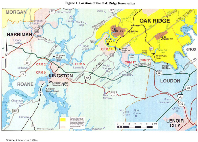
In 1942, during World War II, the U.S. government, under the Manhattan Project initiative, developed the Oak Ridge Reservation (ORR) to produce and study nuclear material needed to make nuclear weapons (ChemRisk 1993b; ORHASP 1999; TDOH 2000). The ORR is located in eastern Tennessee, approximately 15 miles west of Knoxville, and is situated in both Roane and Anderson Counties (ChemRisk 1993b; Jacobs Engineering Group Inc. 1996; ORNL et al. 2002). The southern and western borders of the ORR are formed by the Clinch River, and most of the reservation lies within the Oak Ridge city limits (EUWG 1998). The ORR plants are isolated from the city's populated areas. Figure 1 shows the location of the ORR.
When in 1942 the federal government acquired the ORR, the reservation consisted of 58,575 acres (91.5 square miles). Since that time the federal government has transferred 24,340 (38.0 square miles) of the original 58,575 acres to other parties (e.g., City of Oak Ridge, Tennessee Valley Authority [TVA]), with the U.S. Department of Energy (DOE) maintaining control of the remaining 34,235 acres (53.5 square miles) (Jacobs Engineering Group Inc. 1996; ORNL et al. 2002). Please see Figure 2 for the original and current ORR boundaries.
Under the Manhattan Project, the government constructed four facilities at the ORR. The X-10 site (formerly known as the Clinton Laboratories and now part of what is referred to as the Oak Ridge National Laboratory [ORNL]) was built to produce and separate plutonium. The K-25 site (formerly known as the Oak Ridge Gaseous Diffusion Plant [ORGDP] and now referred to as the East Tennessee Technology Park [ETTP]), the Y-12 plant (now known as the Y-12 National Security Complex), and the former S-50 site (now part of the ETTP) were developed to manufacture enriched uranium (ChemRisk 1993b; Jacobs Engineering Group Inc. 1996; TDEC 2002; TDOH 2000).2
Figure 1. Location of the Oak Ridge Reservation
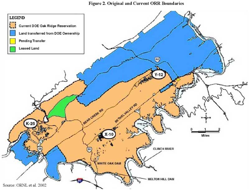
Figure 2. Original and Current ORR Boundaries
X-10 is now known as the Oak Ridge National Laboratory (ORNL). The entire ORNL site encompasses approximately 26,580 acres and is located in Roane County. The main operations at the laboratory take place on about 4,250 acres—the original X-10 site (Bechtel Jacobs Company LLC et al. 1999; ORNL et al. 1999; TDEC 2002).
The X-10 site is about 10 miles southwest of the city center of Oak Ridge, and is surrounded by heavily forested ridges including Chestnut Ridge, Haw Ridge, and Copper Ridge (ChemRisk 1999a; TDOH 2000). The X-10 site is situated within two watersheds: Bethel Valley and Melton Valley (ORNL et al. 1999). Please see Figure 3 for the location of X-10 in relation to Bethel Valley and Melton Valley. The main laboratory at X-10 is located along Bethel Valley Road, within Bethel Valley (ChemRisk 1999a; ORNL et al. 1999). The X-10 site also contains remote facilities and waste storage areas in Melton Valley (ORNL et al. 1999). White Oak Creek, which begins in Bethel Valley, flows in a southerly direction along the eastern border of the plant and travels through a gap in Haw Ridge before entering Melton Valley (ChemRisk 1993b, 1999a). From Melton Valley, White Oak Creek joins the Clinch River at Clinch River Mile (CRM) 20.8 below Melton Hill Dam (ChemRisk 1999a). See Figure 4 for the location of White Oak Creek and the relationship between X-10, White Oak Creek, White Oak Dam, the Clinch River, and the Watts Bar Reservoir.
Before 1963, the Clinch River close to CRM 20.8 was characteristic of a riverine system. Near the mouth of Grassy Creek, at about CRM 14, the Clinch River "becomes wider, the flow decreases, and Watts Bar Reservoir has a greater influence on the water conditions" (Blaylock 2004). Also before 1963, except during floods on the Clinch River, little backflow entered the White Oak Creek Embayment (Hoffman 2005).
After the construction of the Melton Hill Dam was completed in 1963, the flow of the Clinch River changed. In the morning and evening, Melton Hill Dam releases water when power demands are being met. During remaining times of the day, flow past the mouth of White Oak Creek is extremely minimal. The volume of water released on a daily basis during peak periods is about the same as the quantity of releases prior to Melton Hill Dam's construction, although during peak operations the flow past the mouth of White Oak Creek is significantly higher (Blaylock 2004). The water surge into and out of the embayment, caused by daily releases of water from Melton Hill Dam and flood flows in White Oak Creek, eroded sediments containing cesium 137 and other contaminants (SAIC 2005). This large volume of water released from Melton Hill Dam caused a backflow up White Oak Creek Embayment and scoured the embayment sediment (Hoffman 2005). "This increased flow can influence the distribution of radionuclides released from White Oak Creek and the deposition of the radionuclides in the Clinch River" (Blaylock 2004). See Figure 1 for the locations of CRM 20.8 and 14, Melton Hill Dam, Watts Bar Reservoir, Clinch River, and White Oak Creek.
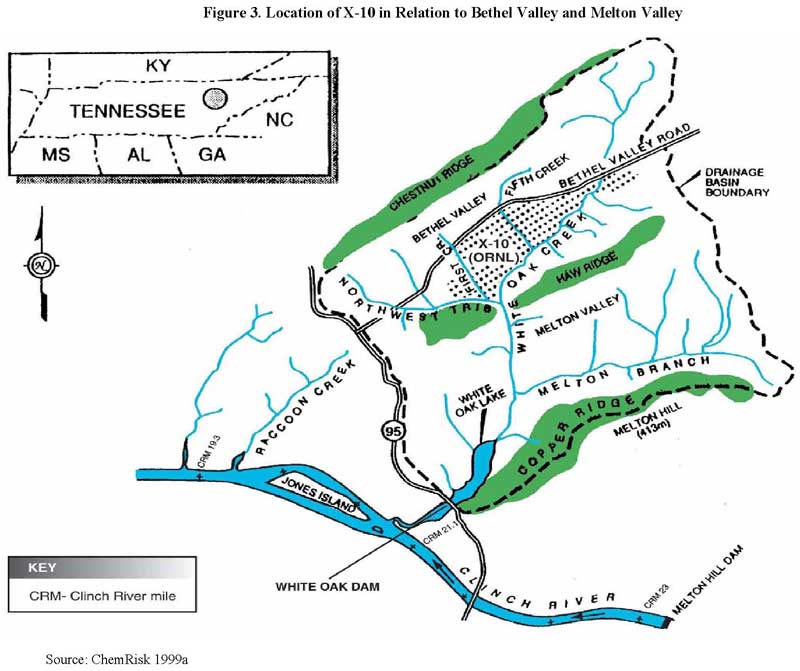
Figure 3. Location of X-10 in Relation to Bethel Valley and Melton Valley
Beginning in the early 1940s, the ORR used radioactive material for various processes, such as uranium enrichment, plutonium production, plutonium separation, and the development of separation processes for additional radionuclides (ChemRisk 1993b; Jacobs Engineering Group Inc. 1996).
The X-10 site was built in 1943 as a "pilot plant" to demonstrate plutonium production and chemical separation. The government had intended to operate the facility for only 1 year. This initial time period was, however, extended indefinitely as operations were continued and expanded at X-10 (ChemRisk 1993b; ChemRisk 1999a; TDOH 2000). Because X-10 was developed to produce and separate plutonium, the main plant contained two parts that were both built in 1943: 1) a plutonium production plant called the "Clinton Pile" and later referred to as the ORNL graphite reactor, and 2) a chemical pilot plant developed to separate and purify plutonium. The chemical pilot plant focused on recovering small amounts of plutonium from fuel that was irradiated in the Clinton Pile (ChemRisk 1993b).
After World War II, the facility broadened its focus to include non-weapons related activities, such as the physical and chemical separation of nuclear fission products, the creation and assessment of nuclear reactors, and the production of a range of radionuclides for global use in the medicinal, industrial, and research disciplines (ChemRisk 1993b; U.S.DOE 1994a). In the 1950s and 1960s, the X-10 site became a worldwide research center to study nuclear energy and to investigate the physical and life sciences that are related to nuclear energy. From 1958 to 1987, the Oak Ridge Research Reactor operated to support various scientific experiments at X-10. For a long period of time, this reactor was the main radionuclide supplier to the "free world" for medical, research, and industrial purposes (Johnson and Schaffer 1992; Stapleton 1992; Thompson 1963).
Following the establishment of the U.S. DOE in the 1970s, the research focus at X-10 was extended to include the study of energy transmission, conservation, and production (UT-Battelle 2003). For more than 50 years, the ORR has been the site for extensive scientific investigation by scores of ecologists and environmental scientists. The ORR is a natural haven for wildlife and plants with many rare and endangered species. Today, the X-10 site receives worldwide recognition as a facility for extensive research and development in several areas of science and technology. In addition, the X-10 site produces numerous radioactive isotopes that have significant uses in medicine and research (TDEC 2002). See Figure 5 for a time line of the major processes at the X-10 site.
The operational history of X-10 is described in greater detail in the 1993 Dose Reconstruction Feasibility Study (ChemRisk 1993b). The main processes and activities that are associated with off-site releases of contaminants from X-10 include: 1) production of radioactive lanthanum (RaLa processing) (1944–1956), 2) Thorex processing of short-decay irradiated thorium (approximately 1954–1960), 3) graphite reactor operations (1943–1963), 4) processing of graphite reactor fuel for plutonium recovery (1943–1945), and 5) waterborne and airborne waste disposal (1943–present). For additional details, please see Section 2.1 and 2.3 of Oak Ridge Health Studies Phase I Report—Volume II—Part A—Dose Reconstruction Feasibility Study. Tasks 1 & 2: A Summary of Historical Activities on the Oak Ridge Reservation with Emphasis on Information Concerning Off-Site Emission of Hazardous Material (ChemRisk 1993b).
Because the government had planned to run the X-10 site for only 1 year, minimal waste had been expected from the facility's chemical separation processes (ChemRisk 1993b; ChemRisk 1999a; Jacobs Engineering Group Inc. 1996). As a result, the intended waste disposal practices quickly proved insufficient for the amount of wastes generated at X-10. When X-10 began operating in 1943, liquid wastes were put into several underground "gunite" tanks3 (ChemRisk 1999a; Jacobs Engineering Group Inc. 1996; ORHASP 1999; Spalding and Boegly 1985). These tanks, which are divided into the North Tank Farm and the South Tank Farm, are located in Bethel Valley within the center of X-10's main facility area (SAIC 2002). Please see Figure 6 for the location of the tanks.
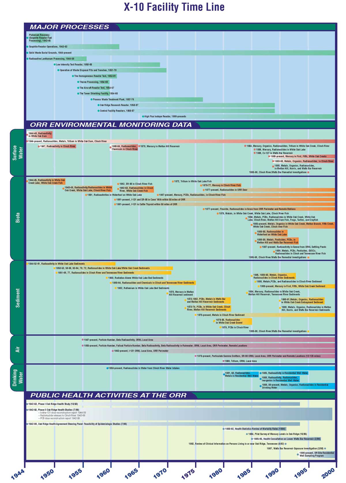
Figure 5. X-10 Facility Time Line
Each gunite tank held 170,000 gallons, but the amount of liquid wastes and sludges quickly filled up the tanks. The sludges were kept in the gunite tanks; however, the liquid wastes were held until enough radioactivity was lost through decay before the liquid waste (combined with diluting water) could be released to White Oak Creek (ChemRisk 1999a; Jacobs Engineering Group Inc. 1996; ORHASP 1999; Spalding and Boegly 1985; USDOE 1996a). The creek received the liquid wastes from the tanks and storm water drainage as it flowed through the X-10 facilities. In June 1944, the 3513 Pond was created as a supplementary settling basin for gunite tank liquids and as a basin where short-lived radionuclides could further decay before being released to White Oak Creek (Jacobs Engineering Group Inc. 1996; Spalding and Boegly 1985).
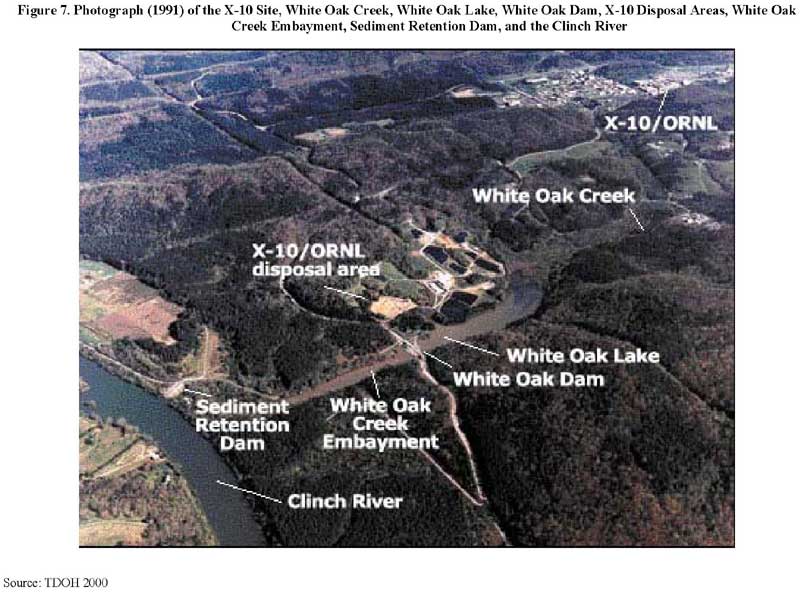
Prior to emptying into the Clinch River, White Oak Creek flows through several contaminated areas in Melton Valley (for example, the old hydrofracture facility) before it runs into White Oak Lake (on-site) (TDOH 2000). This lake was used as a final "settling basin" since 1943 for radionuclides released from X-10 (Blaylock et al. 1993; ChemRisk 1999a; TDOH 2000; USDOE 2002a). See Figure 7 for a photograph (1991) of the X-10 site, White Oak Lake, the X-10 disposal area, and the Clinch River. White Oak Lake was made when White Oak Dam was built across White Oak Creek in 1943. This dam was used as a basin for further settling of the solids that remained (Jacobs Engineering Group Inc. 1996). Please see Figure 4 for the location of White Oak Dam. But some waste products did not settle into the 3513 Pond or White Oak Lake; instead, some of the flow spilled over White Oak Dam into the White Oak Creek Embayment and then reached the Clinch River (TDOH 2000; USDOE 2002a). Most of the wastes released to White Oak Creek are associated with former operations at X-10. This waste includes but is not limited to radionuclides. The X-10 site began discharging radioactive waste to the Clinch River via White Oak Creek in 1943. Thus, the Tennessee Department of Health (TDOH) conducted Task 4 of the Reports of the Oak Ridge Dose Reconstruction, Radionuclide Releases to the Clinch River from White Oak Creek on the Oak Ridge Reservation—an Assessment of Historical Quantities Released, Off-Site Radiation Doses, and Health Risks to evaluate whether off-site populations have been exposed to radioactive waste from X-10 between 1944 and 1991 (the Task 4 dose reconstruction is used to examine past exposures in this public health assessment).
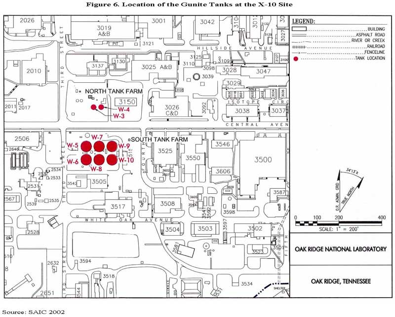
Figure 6. Location of the Gunite Tanks at the X-10 Site
Since 1944, solid wastes generated by X-10 were disposed of at six solid waste storage areas (SWSAs) (USDOE 1994a). The first three SWSAs (1-3) are located in Bethel Valley and the remaining three SWSAs (4-6) are located in Melton Valley (ChemRisk 1993b, 1999a). For a map of these solid waste storage areas, please see Figure 8. Between 1955 and 1963, these waste storage areas were allocated as the Southern Regional Burial Ground by the Atomic Energy Commission. Throughout this time period, the X-10 site functioned as a main disposal location for wastes from more than 50 off-site installations (e.g., Knolls Atomic Power Laboratory, Battelle Memorial Institute), various research facilities, small contractors, several isotope consumers, and Atomic Energy Commission installations (EUWG 1998; Lockheed Martin Energy Systems, Inc. 1998). Please see Table 1 for more information on these disposal areas.
Table 1. Solid Waste Disposal Areas at the X-10 Site
Disposal Area |
Period of Operation |
Status |
Acreage |
|---|---|---|---|
1 |
1943–1944 |
Closed |
1 |
2 |
1944–1946 |
Closed |
4 |
3 |
1946–1951 |
Closed |
6 |
4 |
1951–1959 |
Closed |
23 |
5 |
1959–1973 |
Closed |
50 |
6 |
1969–Unknown |
Closed |
68 |
Source: Bates 1983; TDEC 2006a
While X-10's operations continued, the amount of wastes generated at the site continued to increase. During X-10's early years of operation, after liquid radioactive wastes were initially treated they were pumped into an Intermediate Holding Pond (IHP) adjacent to the east side of SWSA 4 (see Figure 8 for the general location of the IHP next to SWSA 4 and Section II.C.2. for IHP-related remedial activities). The "hottest" radioactive substances decayed in the pond; the radionuclides that did not settle into the pond flowed downstream to the Clinch River (TDEC 2003a). In addition, between 1951 and 1976 the facility alternately used seven unlined "earthen pits" for liquid waste disposal (Spalding and Boegly 1985). A process waste treatment plant (PWTP), shown on Figure 8, was built in 1957 to retrieve fission products from these (and additional) liquid wastes before their disposal (a more advanced facility replaced this in 1976) (USDOE 1994a). In 1960, the "earthen pit" (also known as a low-level waste [LLW] seepage pit) was changed to an "earth-covered trench" (also called a LLW seepage trench) to reduce inadvertent radiation exposure and rainwater buildup.4 Over time, leaks occurred at several of these pits, which resulted in the releases of various radionuclides (Spalding and Boegly 1985).
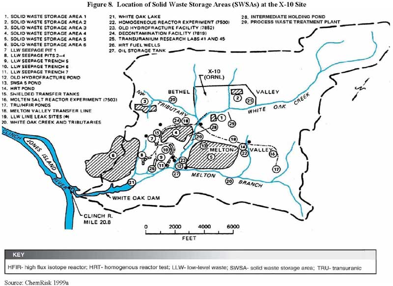
Figure 8. Location of Solid Waste Storage Areas (SWSAs) at the X-10 Site
Trenches were used until 1966, when "hydrofracture technology"5 was initiated for liquid waste disposal (Spaulding and Boegly 1985). The first hydrofracture facility operated between 1964 and 1979; 26 injections were made during this time period. A newer facility started performing injections in June 1982, but this operation was discontinued in 1984 because of uncertainties related to potential leaching into deep groundwater (Boyle et al. 1982; Ohnesorge 1986). ATSDR evaluates hydrofracture technology in its public health assessment on groundwater (available at http://www.atsdr.cdc.gov/HAC/PHA/region_4.html#groundwater).
In addition to releases from disposal areas, radioactive substances were discharged when White Oak Lake was partially drained in October 1955. The lake was drained to give X-10 a greater capacity to handle large discharges and to lessen the chance that ducks would live in the contaminated water (Blaylock et al. 1993). Before it could revegetate, severe rains in 1956 caused a flood that eroded the bottom sediment of White Oak Lake (Blaylock et al. 1993; ChemRisk 1999a). This resulted in the largest discharge of Cs 137 at the lake and also caused radionuclides in particulate form to deposit in the White Oak Creek Embayment. Sedimentation had covered this large amount of released cesium. Eventually, however, with the backflow of water from Melton Hill Dam into the Clinch River, the cesium gradually became uncovered (Hoffman 2005). In the early 1990s, a coffer cell dam was built at the mouth of White Oak Creek to prohibit water backflow to the White Oak Creek Embayment. After this dam was completed, the natural scouring of sediment at the embayment was prevented (ChemRisk 1999a).
DOE predicted that 70% to 80% of radioactive substances released from X-10 to surface waters resulted from seepage at waste disposal areas (USDOE 1988). Mainly because of these disposal practices at X-10 and the heavy rains in 1956, approximately 200,000 curies of radioactive waste were discharged from White Oak Creek into the Clinch River between 1944 and 1991 (ATSDR et al. 2000; TDOH 2000). Please see Table 2 for the estimated discharges of radionuclide releases to the Clinch River via White Oak Creek (Jacobs Engineering Group Inc. 1996). Table 3 is a summary of peak annual releases from White Oak Dam for the eight "key" radionuclides—those that were identified for further evaluation based on a pathway and disease incidence analysis of 24 radionuclides (ChemRisk 2000). For additional details regarding the radioactive waste disposal history of the X-10 site, please see Section 2.1.5 of Oak Ridge Health Studies Phase I Report—Volume II—Part A—Dose Reconstruction Feasibility Study. Tasks 1 & 2: A Summary of Historical Activities on the Oak Ridge Reservation with Emphasis on Information Concerning Off-Site Emission of Hazardous Material (ChemRisk 1993b) and also Section 2.0 of Task 4 of the Reports of the Oak Ridge Dose Reconstruction, Radionuclide Releases to the Clinch River from White Oak Creek on the Oak Ridge Reservation—an Assessment of Historical Quantities Released, Off-Site Radiation Doses, and Health Risks (ChemRisk 1999a). For information on current remedial activities, see Sections II.C.1. (Bethel Valley Watershed), II.C.2. (Melton Valley Watershed), and II.C.3. (Off-Site Locations) in this document.
Table 2. Estimated Discharges (in curies) of Radionuclides From White Oak Creeka
Year |
Cs 137 |
Ru 106 |
Sr 90 |
TRE b |
Ce 144 |
Zr 95 |
I 131 |
Co 60 |
H 3 |
TRUc |
|---|---|---|---|---|---|---|---|---|---|---|
1949 |
77 |
110 |
150 |
77 |
18 |
180 |
77 |
0.04 |
||
1950 |
19 |
23 |
38 |
30 |
15 |
19 |
0.04 |
|||
1951 |
20 |
18 |
29 |
11 |
5 |
18 |
0.08 |
|||
1952 |
10 |
15 |
72 |
26 |
23 |
19 |
20 |
0.03 |
||
1953 |
6 |
26 |
130 |
110 |
7 |
8 |
2 |
0.08 |
||
1954 |
22 |
11 |
140 |
160 |
24 |
14 |
4 |
0.07 |
||
1955 |
63 |
31 |
93 |
150 |
85 |
5 |
7 |
7 |
0.25 |
|
1956 |
170 |
29 |
100 |
140 |
59 |
12 |
4 |
46 |
0.28 |
|
1957 |
89 |
60 |
83 |
110 |
13 |
23 |
1 |
5 |
0.15 |
|
1958 |
55 |
42 |
150 |
240 |
30 |
6 |
8 |
9 |
0.08 |
|
1959 |
76 |
520 |
60 |
94 |
48 |
27 |
1 |
77 |
0.68 |
|
1960 |
31 |
1,900 |
28 |
48 |
27 |
38 |
5 |
72 |
0.19 |
|
1961 |
15 |
2,000 |
22 |
24 |
4 |
20 |
4 |
31 |
0.07 |
|
1962 |
6 |
1,400 |
9 |
11 |
1 |
2 |
0.4 |
14 |
0.06 |
|
1963 |
4 |
430 |
8 |
9 |
2 |
0.3 |
0.4 |
14 |
0.17 |
|
1964 |
6 |
190 |
7 |
13 |
0.3 |
0.2 |
0.3 |
15 |
1,900 |
0.08 |
1965 |
2 |
69 |
3 |
6 |
0.1 |
0.3 |
0.2 |
12 |
1,200 |
0.50 |
1966 |
2 |
29 |
3 |
5 |
0.1 |
0.7 |
0.2 |
7 |
3,100 |
0.16 |
1967 |
3 |
17 |
5 |
9 |
0.2 |
0.5 |
0.9 |
3 |
13,300 |
1.03 |
1968 |
1 |
5 |
3 |
4 |
0.03 |
0.3 |
0.3 |
1 |
9,700 |
0.04 |
1969 |
1 |
2 |
3 |
5 |
0.02 |
0.2 |
0.5 |
1 |
12,200 |
0.20 |
1970 |
2 |
1 |
4 |
5 |
0.06 |
0.02 |
0.3 |
1 |
9,500 |
0.40 |
1971 |
1 |
0.5 |
3 |
3 |
0.05 |
0.01 |
0.2 |
1 |
8,900 |
0.05 |
1972 |
2 |
0.5 |
6 |
5 |
0.03 |
0.01 |
0.3 |
1 |
10,600 |
0.07 |
1973 |
2 |
0.7 |
7 |
0.02 |
0.05 |
0.5 |
1 |
15,000 |
0.08 |
|
1974 |
1 |
0.2 |
6 |
0.02 |
0.02 |
0.2 |
0.6 |
8,600 |
0.02 |
|
1975 |
0.6 |
0.3 |
7 |
0.3 |
0.5 |
11,000 |
0.02 |
|||
1976 |
0.2 |
0.2 |
5 |
0.03 |
0.9 |
7,400 |
0.01 |
|||
1977 |
0.2 |
0.2 |
3 |
0.03 |
0.4 |
6,200 |
0.03 |
|||
1978 |
0.3 |
0.2 |
2 |
0.04 |
0.4 |
6,300 |
0.03 |
|||
1979 |
0.2 |
0.1 |
2.4 |
0.04 |
0.4 |
7,700 |
0.03 |
|||
1980 |
0.6 |
0 |
1.5 |
0.04 |
0.4 |
4,600 |
0.04 |
|||
1981 |
0.2 |
0.1 |
1.5 |
0.04 |
0.7 |
2,900 |
0.04 |
|||
1982 |
1.5 |
0.2 |
2.7 |
0.06 |
1.0 |
5,400 |
0.03 |
|||
1983 |
1.2 |
0.2 |
2.1 |
0.004 |
0.3 |
5,600 |
0.05 |
|||
1984 |
0.6 |
0.2 |
2.6 |
0.05 |
0.2 |
6,400 |
0.03 |
|||
1985 |
0.4 |
0.007 |
3.0 |
0.6 |
3,700 |
0.008 |
||||
1986 |
1.0 |
0 |
1.8 |
0.54 |
2,600 |
0.024 |
||||
1987 |
0.6 |
0 |
1.2 |
0.12 |
2,500 |
0.006 |
||||
1988 |
0.4 |
0 |
1.1 |
<0.07 |
1,700 |
|||||
1989 |
1.2 |
0 |
2.9 |
0.13 |
4,100 |
|||||
1990 |
1.1 |
0 |
3.1 |
0.12 |
3,100 |
|||||
1991 |
1.7 |
2.7 |
0.12 |
2,100 |
||||||
1992 |
0.6 |
2.1 |
0.04 |
1,900 |
||||||
1993 |
0.5 |
2.1 |
0.04 |
1,700 |
||||||
1994 |
0.5 |
2.8 |
0.07 |
2,200 |
||||||
Total |
699.6 |
6,931.6 |
1,214.6 |
1,295 |
341.93 |
376.61 |
175.33 |
325.58 |
183,100 |
5.248 |
Source: Blaylock et al. 1993; Martin Marietta Energy Systems, Inc. 1992, 1993; USDOE 1988
a All digits were carried through to avoid any errors from rounding numbers. Only the first two are significant.
b Total of rare earth elements, excluding cerium.
c Transuranic radionuclides.
Blank cells indicate that no data were reported.
The four radionuclides expected to be of most concern are highlighted in gray.
Table 3. Summary of Peak Annual Releases From White Oak Dam for the Eight Key Radionuclides (1944–1991)
Peak Annual Releases (curies) |
Number of Years at 10% of Peak Release or More |
|||
|---|---|---|---|---|
Radionuclide |
Lower Bound |
Central Estimate |
Upper Bound |
|
| Cesium 137 | 50 |
200 |
510 |
14 |
Ruthenium 106 |
1,600 |
2,100 |
2,700 |
5 |
Strontium 90 |
68 |
190 |
390 |
18 |
Cobalt 60 |
64 |
85 |
110 |
15 |
Cerium 144 |
70 |
94 |
120 |
13 |
Zirconium 95 |
72 |
210 |
440 |
9 |
Niobium 95 |
17 |
200 |
520 |
10 |
Iodine 131 |
10 |
68 |
190 |
10 |
Source: ChemRisk 2000
Annual estimates were based on data in log books, interviews with knowledgeable parties, and laboratory documents.
II.C. Remedial and Regulatory History
The Federal Facility Agreement was implemented at the ORR on January 1, 1992. This is a legally binding agreement used to establish schedules, procedures, and documentation for remedial activities at the ORR (EUWG 1998). The Federal Facility Agreement is available online at http://www.bechteljacobs.com/pdf/ffa/ffa.pdf |
As a result of several on-site processes that produced nonradioactive and radioactive wastes, on November 21, 1989, EPA listed the ORR on the final National Priorities List (NPL) (EUWG 1998; USDOE 2001a; USEPA 2002a). The DOE is performing remediation activities at the reservation under a Federal Facility Agreement (FFA), which is an interagency agreement between the DOE, EPA, and TDEC. The EPA and TDEC, along with the public, help DOE select the details for remedial actions at the ORR (USDOE 2003a). These parties work collaboratively to ensure that adequate remediation activities are used, and to ensure that hazardous waste related to previous and current ORR activities is completely studied and appropriate remedial action is taken (USDOE 1996b, 2003a). DOE is conducting its investigations of the ORR under the Comprehensive Environmental Response, Compensation, and Liability Act (CERCLA), a program that requires an FFA be established for all NPL sites owned by the federal government (EUWG 1998; USEPA 2002b). In addition, DOE is incorporating response procedures designated by CERCLA, with mandatory actions from the Resource Conservation and Recovery Act (RCRA) (USEPA 2002b). See Figure 5 for a time line of major processes, environmental data, and public health activities associated with the X-10 site.
Radioactive waste material, such as Cs 137 and Sr 90, is present in old waste sites at the ORR. These waste sites constitute 5% to 10% of the reservation. Releases from these waste sites, as well as leaching caused by abundant rainfall and high water tables, have contributed to the radionuclide contamination of surface water, groundwater, soil, and sediments at the ORR (EUWG 1998). According to DOE, waste sites located in the Melton Valley Watershed "…are the primary contributors to off-site spread of contaminants" from the ORR and White Oak Creek flows through or past these areas (USDOE 2002b).
In 1986, DOE began remedial actions at the ORR under a RCRA permit. Since that time, DOE has started about 50 response activities under the FFA that address waste disposal and contamination issues on the reservation (USEPA 2002a). To facilitate the investigation and remediation of contamination related to the reservation, the contaminated areas on the ORR were separated into five large tracts of land that are typically associated with the major hydrologic watersheds (EUWG 1998). More specifically, the contaminated areas associated with X-10 are located in the Bethel Valley Watershed and the Melton Valley Watershed (USDOE 2001b). Please refer to Figure 9 for the locations of these two watersheds.
Although not current public health concerns, some of these former waste disposal sites are nonetheless subject to remediation. DOE is remediating these sites to ensure long-term safety and to prevent off-site releases. More information on DOE's environmental management program can be obtained at http://www.oakridge.doe.gov/External/Default.aspx?tabid=42 ![]() .
.
II.C.1. Bethel Valley Watershed
The major operations at X-10 take place within the Bethel Valley Watershed. The main plant, key research facilities, primary administrative offices, as well as various forms of waste sites, are situated in Bethel Valley. Over the past 60 years, X-10 releases have contaminated the Bethel Valley Watershed. Mobile contaminants primarily leave the Bethel Valley Watershed via White Oak Creek. These contaminants travel from the Bethel Valley Watershed to the Melton Valley Watershed, where further contaminants enter White Oak Creek. Then, the contaminants that have been discharged to White Oak Creek are released over White Oak Dam and into the Clinch River (USDOE 2001b).
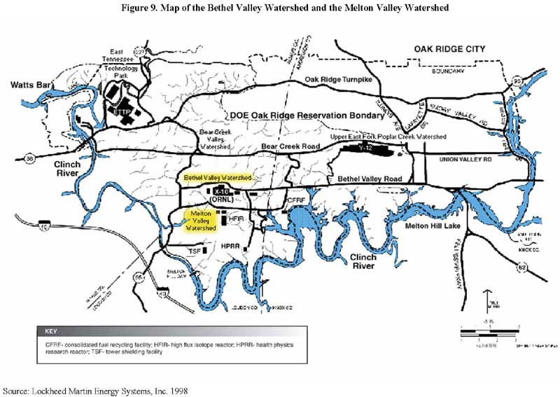
Figure 9. Map of the Bethel Valley Watershed and the Melton Valley Watershed
Many remedial activities have been conducted in Bethel Valley to protect human health and the environment in the present and future. These actions, which comply with federal and state requirements, have removed the most contaminated materials (including source and leaching materials) and reduced the amount of contaminants in Bethel Valley. Main remedial activities conducted in Bethel Valley associated with X-10 operations have included 1) groundwater treatment and extraction at the Corehole 8 Plume, 2) sludge and liquid waste removal at the Gunite and Associated Tanks (GAAT), 3) liquid and solid waste removal and treatment at the inactive liquid low-level waste tanks, and 4) contaminated sediment removal from the surface impoundments operable unit (SAIC 2002, 2004; USDOE 2001c). In addition, in May 2002 a Record of Decision (ROD) was signed to address several interim remedial actions in Bethel Valley. As of the 2004 fiscal year, ROD-initiated activities—including a groundwater study—had begun (SAIC 2005). Please see Figure 10 for a map of Bethel Valley that includes these areas. The main remedial activities conducted in Bethel Valley are detailed further in Appendix B.
II.C.2. Melton Valley Watershed
X-10 disposed of its radioactive wastes (liquid and solid) in Melton Valley, and also operated its experimental facilities within this watershed (USDOE 2002a, 2002b). Discharges from Melton Valley's waste areas have produced secondary contamination sources that include sediment, groundwater, and soil contamination. Furthermore, contaminants discharged from Melton Valley travel off the reservation through surface water and flow into the Clinch River (SAIC 2002). As a result, the waste sites in the Melton Valley Watershed "...are the primary contributors to off-site spread of contaminants" from the ORR (USDOE 2002b).
Many remedial activities, which comply with federal and state requirements, have been conducted in Melton Valley. These actions—undertaken to protect human health and the environment in the present and future—have removed the most contaminated materials and reduced the amount of contaminants in Melton Valley. Main remedial activities related to X-10 operations and the White Oak Creek study area (see Figure 11) have included 1) removing contaminated soil and restricting access to the Cesium Plots Research Facility, 2) building a sediment retention structure at the mouth of White Oak Creek to reduce off-site movement of sediments to the Watts Bar Reservoir and the Clinch River, 3) reducing releases of strontium 90 into White Oak Creek from waste area grouping (WAG) 4 trenches, 4) installing a groundwater treatment unit at WAG 5 to prevent strontium 90 from entering Melton Branch, and 5) injecting radioactive waste and grout below ground and removing liquid low-level waste (LLLW) underground storage tanks (USTs) from the Old Hydrofracture Facility (OHF) (SAIC 2002; USDOE 2002c; USEPA 2002a). A ROD signed in September 2000 focused on remedial activities to prevent contaminant releases into surface waters and groundwater in Melton Valley (SAIC 2002, 2004). Please see Figure 12 for a map of Melton Valley that includes these areas. The main remedial activities conducted in Melton Valley are further detailed in Appendix B.

Figure 10. Map of the Major Remedial Activities in Bethel Valley
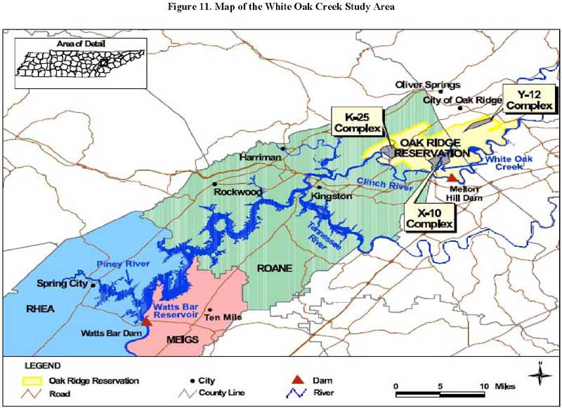
Figure 11. Map of the White Oak Creek Study Area
This section discusses remedial activities that have been conducted at two off-site locations related to X-10 that are located within the White Oak Creek Public Health Assessment study area: the Clinch River/Poplar Creek Operable Unit (OU) and the Lower Watts Bar Reservoir OU (SAIC 2002). The White Oak Creek study area (see Figure 11) consists of the area along the Clinch River, from the Melton Hill Dam to the Watts Bar Dam. The Lower Watts Bar Reservoir is downstream of the ORR, extending from the confluence of the Clinch and Tennessee Rivers to the Watts Bar Dam (USDOE 1995a). As a result, the Clinch River and the Lower Watts Bar Reservoir have received contaminants related to X-10 operations (Jacobs EM Team 1997b; USDOE 1995a; USDOE 2001a). See Figure 1 and Figure 4 for these surface water locations.
Remedial actions at the Clinch River/Poplar Creek OU and the Lower Watts Bar Reservoir OU, which were undertaken to protect human health and the environment in the present and future, comply with federal and state guidelines (Jacobs EM Team 1997b; USDOE 1995a). Remedial activities at these OUs are summarized below.

Figure 12. Map of the Major Remedial Activities in Melton Valley
In 1996, a remedial investigation/feasibility study (RI/FS) was conducted to examine the past and present releases to off-site surface water and to determine if remedial action was necessary (ATSDR et al. 2000). The RI/FS concluded that the Clinch River/Poplar Creek OU presented two main risks by exposure to 1) fish tissue that contained chlordane, mercury, PCBs, and arsenic; and 2) deep sediments in the primary river channel that contained arsenic, mercury, cesium 137, and chromium (Jacobs EM Team 1997b; Jacobs Engineering Group Inc. 1996; SAIC 2002; USDOE 2001a). The largest concentrations of radionuclides that have been detected are buried between 8 and 32 inches into the deep sediments (Jacobs EM Team 1997b).
A baseline risk assessment was conducted. It suggested that consumption of certain fish contaminated with PCBs posed the greatest risk to public health. In addition, fish contaminated with chlordane, mercury, and arsenic presented the possible chance of causing health effects. The assessment also determined that because of PCB and mercury contamination, the consumption of any type of fish in Poplar Creek posed a health risk. Similarly, consumption of bass from the Clinch River below Melton Hill Dam posed a health risk due to PCB contamination. Still, no primary risks were associated with exposure to radionuclides in fish from the Clinch River or from Poplar Creek. Furthermore, the risk assessment determined that contaminants in deep-water sediments would present a health risk only if they were dredged; no exposure pathway currently exists to the deep-water sediments (Jacobs EM Team 1997b).
In September 1997, DOE issued a Record of Decision for the Clinch River/Poplar Creek OU. EPA and TDEC—supportive agencies for this response action—agree with the remedial actions selected for this OU. The chosen actions, which comply with federal and state requirements, were undertaken to protect human health and the environment in the present and future. The following remedial actions were selected for the OU:
These institutional controls are developed under an interagency agreement (IAG) established by DOE, EPA, TVA, TDEC, and the U.S. Army Corps of Engineers (USACE) in February 1991. The IAG allows these agencies to work cooperatively through the Watts Bar Interagency Agreement to review permitting and all other activities that could result in disturbing the sediment (for example, building a dock or erecting a pier) (ATSDR 1996; Jacobs EM Team 1997b; USDOE 2003a). Please see page 3-12 of the ROD at http://www.epa.gov/superfund/sites/rods/fulltext/r0497075.pdf ![]() for more details. For additional information on institutional controls to prevent sediment-disturbing activities, please see Rules of the Tennessee Department of Environment and Conservation, Chapter 1200-4-7, Aquatic Resource Alteration Permit Process; Section 26A of the Tennessee Valley Authority Act of 1933; and Section 10 of the Rivers and Harbors Act of 1910 (U.S.A.C.E.) (Jacobs EM Team 1997b).
for more details. For additional information on institutional controls to prevent sediment-disturbing activities, please see Rules of the Tennessee Department of Environment and Conservation, Chapter 1200-4-7, Aquatic Resource Alteration Permit Process; Section 26A of the Tennessee Valley Authority Act of 1933; and Section 10 of the Rivers and Harbors Act of 1910 (U.S.A.C.E.) (Jacobs EM Team 1997b).
In February 1991, DOE, EPA, TVA, TDEC, and USACE established an interagency agreement. Under this agreement, these agencies collaboratively work through the Watts Bar Interagency Agreement to review permitting and other activities that could possibly disturb sediment, such as erecting a pier or building a dock (ATSDR 1996; Jacobs EM Team 1997b; USDOE 2003a). For more details, see the ROD at http://www.epa.gov/superfund/sites/rods/fulltext/r0497075.pdf |
In February 1998, a Remedial Action Report (RAR) was approved. This report recommended that monitoring be conducted for surface water, fish, sediment, and turtles in the Clinch River/Poplar Creek OU (ATSDR et al. 2000). Since this time, annual surface water sampling, sediment monitoring, and fish and turtle sampling have been conducted at the Clinch River/Poplar Creek OU (SAIC 2002; USDOE 2001a). Institutional controls are also used to examine activities that could result in movement of the sediments, and the Tennessee Wildlife Resources Agency (TWRA) prints fish consumption advisories in its Tennessee Fish Regulations (SAIC 2002).
In September 1995, DOE issued a Record of Decision for the Lower Watts Bar Reservoir OU. EPA and TDEC, which are supportive agencies for this response action, agree with the remedial actions selected for this OU. The chosen actions were undertaken to protect human health and the environment in the present and future, and comply with federal and state requirements. The following contaminants of concern (COCs) were identified at the OU: 1) mercury, arsenic, PCBs, chlordane, and aldrin in fish; 2) mercury, chromium, zinc, and cadmium in dredged sediments and sediments used for growing food products; and 3) manganese through ingestion of surface water (ATSDR et al. 2000; SAIC 2002; USDOE 2001a, 2003b). The largest threat to public health from the Lower Watts Bar Reservoir is related to the consumption of PCB-contaminated fish (SAIC 2002; USDOE 2001a, 2003b). The ROD concluded that if the deep sediments were kept in place, then "...these sediments do not pose a risk to human health because no exposure pathway exists (USDOE 1995a)."
The remedial activities selected for the Lower Watts Bar Reservoir have included using preexisting institutional controls to decrease contact with contaminated sediment, fish consumption advisories printed in the Tennessee Fish Regulations, and yearly monitoring of biota, sediment, and surface water (ATSDR et al. 2000; SAIC 2002; USDOE 1995a, 2001a, 2003b; USEPA 2002a). The interagency agreement established by DOE, EPA, TVA, TDEC, and USACE in February 1991 allows these agencies to work cooperatively through the Watts Bar Interagency Agreement to review permitting and all other activities that could result in disturbing the sediment, such as building a dock or erecting a pier (ATSDR 1996; Jacobs EM Team 1997b; USDOE 2003a). According to the interagency agreement, DOE is required to take action if an institutional control is not effective or if a sediment-disturbing activity could cause harm (Jacobs EM Team 1997b; USDOE 2003a). For more details, please see page 3-5 of the Lower Watts Bar Reservoir ROD at http://www.epa.gov/superfund/sites/rods/fulltext/r0495249.pdf ![]() and the Clinch River/Poplar Creek OU ROD at http://www.epa.gov/superfund/sites/rods/fulltext/r0497075.pdf
and the Clinch River/Poplar Creek OU ROD at http://www.epa.gov/superfund/sites/rods/fulltext/r0497075.pdf ![]() . For additional information on institutional controls to prevent sediment-disturbing activities, please see Rules of the Tennessee Department of Environment and Conservation, Chapter 1200-4-7, Aquatic Resource Alteration Permit Process; Section 26A of the Tennessee Valley Authority Act of 1933; and Section 10 of the Rivers and Harbors Act of 1910 (U.S.A.C.E.) (Jacobs EM Team 1997b).
. For additional information on institutional controls to prevent sediment-disturbing activities, please see Rules of the Tennessee Department of Environment and Conservation, Chapter 1200-4-7, Aquatic Resource Alteration Permit Process; Section 26A of the Tennessee Valley Authority Act of 1933; and Section 10 of the Rivers and Harbors Act of 1910 (U.S.A.C.E.) (Jacobs EM Team 1997b).
II.D. Land Use and Natural Resources
When the government acquired the ORR in 1942, it reserved a section of the reservation (about 14,000 acres out of the total of approximately 58,575) for housing, businesses, and support services (ChemRisk 1993c; ORNL et al. 2002). In 1959, that section of the ORR was turned into the independently governed city of Oak Ridge. This self-governing area has parks, homes, stores, schools, offices, and industrial areas (ChemRisk 1993c).
The majority of residences in Oak Ridge are located along the northern and eastern borders of the ORR (Bechtel Jacobs Company LLC et al. 1999). Since the 1950s, however, the urban population of Oak Ridge has grown toward the west. As a result of this expansion, the property lines of many homes in the city's western section border the ORR property (Faust 1993). Apart from these urban sections, the areas close to the ORR continue to be mainly rural, as they have historically been (Bechtel Jacobs Company LLC et al. 1999; ChemRisk 1993c). The closest homes to X-10 are located near Jones Island, about 2.5 to 3.0 miles southwest of the main facility (ChemRisk 1993c).
In 2002, the ORR measured 34,235 acres, which includes the three main DOE facilities: Y-12, X-10, and K-25 (ORNL et al. 2002). The majority of the ORR is situated within the city limits of Oak Ridge. These DOE facilities constitute approximately 30% of the reservation; the remaining 70% of the reservation was turned into the National Environmental Research Park in 1980. This park was created so that protected land could be used for environmental education and research, and to show that the development of energy technology could be compatible with a quality environment (EUWG 1998). A large amount of land at the ORR that was formerly cleared for farmland has grown into full forests over the past several decades. Sections of this land contain areas called "deep forest" that include flora and fauna considered ecologically significant, and portions of the reservation are regarded as biologically rich (SAIC 2002).
Today, the entire ORNL site encompasses approximately 26,580 acres. The main operations at the ORNL take place on about 4,250 acres, which was formerly known as the X-10 site. The remaining acres are divided between the Oak Ridge National Environmental Research Park (21,980 acres) and the Solway Bend area that is used for environmental monitoring (350 acres) (ORNL et al. 1999). The X-10 site contains approximately 517 buildings, trailers, and additional facilities, which total over 3.4 million square feet. There are additional facilities related to X-10 operations, but these are situated at the Y-12 plant and at off-site locations. Of the X-10 facilities and those at the other locations, however, 156 are inactive or are expected to be inactive in the future (Bechtel Jacobs Company LLC et al. 1999).
Historically, forestry and agriculture (beef and dairy cattle) have constituted the primary uses of land in the area around the reservation; but these land uses are both declining. For several years, milk produced in the area was bottled for local distribution, whereas beef cattle from the area were sold, slaughtered, and nationally distributed. In addition, tobacco, soybeans, corn, and wheat were the primary crops grown in the area. Also, small game and waterfowl were hunted on a regular basis in the ORR area, but deer were hunted during specific time periods. Waterfowl and small game hunting regularly occurs within the ORR area, while deer hunting occurs annually on the ORR (ChemRisk 1993c). During the annual deer hunts, radiological monitoring is conducted on all deer prior to their release to the hunters. Monitoring is conducted to ensure that none of the animals contain quantities of radionuclides that could cause "significant internal exposure" to the consumer (Teasley 1995).
The southern and western boundaries of the ORR are formed by the Clinch River; Poplar Creek and East Fork Poplar Creek drain the ORR to the north and west (Jacobs EM Team 1997b). White Oak Creek, which travels south along the eastern border of the X-10 site, flows into White Oak Lake, over White Oak Dam, and into the White Oak Creek Embayment before meeting the Clinch River at CRM 20.8 (ChemRisk 1993b, 1999a; TDOH 2000; USDOE 2002a). Ultimately, every surface water system on the reservation drains into the Clinch River (ChemRisk 1993b). The Lower Watts Bar Reservoir is situated downstream of the ORR, extending from the confluence of the Clinch and Tennessee Rivers to the Watts Bar Dam (USDOE 1995a). As a result, the Clinch River and the Lower Watts Bar Reservoir have received contaminants associated with X-10 operations (Jacobs EM Team 1997b; USDOE 1995a; USDOE 2001a). Please see Figure 4 for these relative water systems.
The majority of land around the Clinch River and the Lower Watts Bar Reservoir is undeveloped and wooded. Other than activities at the ORR, there is minimal industrial development in these surrounding areas, and there is a fair amount of residential growth. The public has access to the Clinch River and to the Lower Watts Bar Reservoir, which it uses for recreational purposes such as boating, swimming, fishing, water skiing, and shoreline activities (USDOE 1996d, 2001b, 2003b).
Kingston, Spring City, and Rockwood maintain public water supplies in the vicinity of the Oak Ridge Reservation (Figures 13 and 14 show these water intake and city locations, respectively, that are all within the White Oak Creek study area). The Kingston water supply has two water intakes, but only one of the intakes—located upstream on the Tennessee River in Watts Bar Lake at Tennessee River Mile (TRM) 568.4—would potentially be affected by ORR contaminants (Hutson and Morris 1992; G. Mize, Tennessee Department of Environment and Conservation, Drinking Water Program, personal communication re: Kingston public water supply, 2004). Spring City obtains its water from an intake on the Piney River branch of Watts Bar Lake (Hutson and Morris 1992). The city of Rockwood receives its water from an intake on the King Creek branch of Watts Bar Lake, located at TRM 552.5 (TDEC 2001, 2006b; TVA 1991). Still, only reverse flow conditions could potentially affect any of these three intakes (ATSDR 1996).
Under the Safe Drinking Water Act, the EPA has since 1974 set health-based standards for substances in drinking water and specified treatments for providing safe drinking water (USEPA 1999a). The public water supplies for Kingston, Spring City, and Rockwood are continually monitored for these regulated substances, which include 15 inorganic contaminants, 51 synthetic and volatile organic contaminants, and 4 radionuclides. For EPA's monitoring schedules, see http://www.epa.gov/safewater/pws/pdfs/qrg_smonitoringframework.pdf ![]() (EPA 2004a).
(EPA 2004a).
To ask specific questions related to your drinking water, please call TDEC's Environmental Assistance Center in Knoxville, Tennessee at 865-594-6035. To find additional information related to your water supply or other water supplies in the area, please call EPA's Safe Drinking Water Hotline at 800-426-4791 or visit EPA's Safe Drinking Water Web site at http://www.epa.gov/safewater |
According to EPA's Safe Drinking Water Information System (SDWIS), the Kingston, Spring City, and Rockwood public water supply systems have not had any significant violations (USEPA 2004b). To look up information related to these and other public water supplies, go to EPA's Local Drinking Water Information Web Site at http://www.epa.gov/safewater/dwinfo.htm ![]() . In addition, in 1996 TDEC's DOE Oversight Division started to participate in EPA's Environmental Radiation Ambient Monitoring System (ERAMS). Under this program, TDEC collects finished drinking water samples from the Kingston Water Treatment Plant on a quarterly basis and then submits the samples to EPA for radiological analyses (TDEC 2002, 2003a). Please see the TDEC–DOE Oversight Division's annual report to the public at http://www.state.tn.us/environment/doeo/active.shtml
. In addition, in 1996 TDEC's DOE Oversight Division started to participate in EPA's Environmental Radiation Ambient Monitoring System (ERAMS). Under this program, TDEC collects finished drinking water samples from the Kingston Water Treatment Plant on a quarterly basis and then submits the samples to EPA for radiological analyses (TDEC 2002, 2003a). Please see the TDEC–DOE Oversight Division's annual report to the public at http://www.state.tn.us/environment/doeo/active.shtml ![]() for a summary of radiological drinking water sampling results. TDEC has also conducted filter backwash sludge sampling at Spring City because contaminants from the reservation could potentially move downstream into community drinking water supplies (TDEC 2003b). Additional information on TDEC's participation in the ERAMS program is provided in Section II.F.3. of this document.
for a summary of radiological drinking water sampling results. TDEC has also conducted filter backwash sludge sampling at Spring City because contaminants from the reservation could potentially move downstream into community drinking water supplies (TDEC 2003b). Additional information on TDEC's participation in the ERAMS program is provided in Section II.F.3. of this document.
Next Section Table of Contents