NAVAL AIR FACILITY, ADAK
(a/k/a ADAK NAVAL AIR STATION)
ADAK, ALEUTIAN ISLANDS CENSUS, ALASKA
ENVIRONMENTAL CONTAMINATION
AND HUMAN EXPOSURE PATHWAYS (cont.)
B. Recreational or Construction Activities - Active Exposures
B1. Explosive and Physical Hazards Pose a Low
Hazard to Adults and Children in the Downtown Area as a Result of Walking,
Hiking, Fishing, Playing, Digging, Snowmobiling, 4-Wheel Driving, or Digging
-
Current and Future Exposure - Public Health Hazard
Although the likelihood of people being injured or killed by unexploded
ordnance materials, or Rommel stakes during routine daily activities is extremely
low, potential current and future hazards still exist and cannot be entirely
eliminated for people recreating in the downtown area. Surveys, screening, intrusive
sampling, and historical information reviews have been conducted on areas in
the downtown region to help establish the potential level of hazard for people
to come in contact with unexploded ordnance. The Navy has performed extensive
investigations and removal actions that will continue as part of the remedial
investigation process of Operable Unit B (OU-B). The Navy has determined that
the downtown area does not pose an unacceptable hazard level to people who live,
work, or play downtown. To reduce the likelihood of people to handle explosive
and physical hazards, the Navy initiated and continues to educate people on
the possible appearance of hazardous and explosive item and the procedure for
notifying the correct officials.
Background
The presence of explosives and military-specific physical hazards has been a part of the history of Adak
since World War II. Explosive and incendiary devices were laid to deter foreign intruders, stored at,
transported from, and disposed on the military occupied areas of Adak, mostly occurring between 1942
and 1946. Additionally, extensive hands-on training of war-time personnel has contributed to the
presence of unexploded ordnance and military-specific stakes. Despite extensive efforts to remove
known ordnance and stakes, some may remain in the ground today.
The Navy has used the latest techniques and methods available to determine the speculated hazards
posed by OE/UXO hazards at Adak. Initially, the Navy used the SiteStats/GridStats software and the
Ordnance and Explosives Cost-Effectiveness Risk Tool (OECert). This method which has been widely
used at other military installations call for collecting samples of only a small percent (statistical
sampling of approximately 3%) of the area and applying the results in predicting the hazards for the
entire area. This method makes certain assumptions about the conditions which ATSDR believed could
not be accurately applied at Adak. The methodology assumed that the study area is homogenous or has
the same characteristics: terrain, soil composition and consistency, same type of OE/UXO, same
probability of OE/UXO penetration depths, etc. (Foster Wheeler 1998c) Typically, this methodology
has been used for studying firing ranges in which a well-defined area has been used for a specific type
of ordnance for training purposes (UASEC, NEODTD 1999). In such cases, the OE is released from
a defined place toward a defined target area. On Adak, the downtown area was not used as a firing
range. OE/UXO present in the downtown area most likely resulted from accidental releases from storage
areas, during transport operations, or from souvenir collectors who brought OE/UXO from other areas
to their quarters or work area.
For the Navy's 1996-1998 unexploded ordnance studies, the downtown area was selected as high
priority and divided into three priority areas. See Figure 5 for specific boundaries. Each priority area
was investigated similarly. Each priority area was divided into grids. Priority I area consisted of
approximately 390 acres divided into grids 164 feet by 164 feet in size. Priority II area consisted of
approximately 683 acres also divided into grids 164 feet by 164 feet in size. The combined total area
of Priority I and II Area is 1083 grids (Foster Wheeler 1997). Priority III area consisted of
approximately 1,334 acres divided into 1,453 grids 200 feet by 200 feet in size (Foster Wheeler 1998c).
Priority I Area -Consists of the majority of the essential reuse facilities such as housing,
administrative buildings, schools, and industrial areas.
Priority II Area -Consists of unused housing areas, airfield support areas, taxiways, runways, and
the fuel tank farm.
Priority III Area -Consists of the unoccupied "barracks," the power plant, utilities support
buildings, and contractor's construction camp. Most of the area, however, is undeveloped tundra.
The studies each involved six phases of work.
Historical Records and Archive Search - Records from 1943 to the present were reviewed from
boxes of files that have been declassified and other non classified files. Information provided an idea of proposed minefield locations.
Physical Survey - A physical survey of the areas investigated was done to establish a reference
grid system on which the survey could be based. The boundaries of the investigation areas were
established. Grids were delineated and a statistical number of grids selected for the Geophysical
Investigation using the SiteStats/GridStats software package.
Surface Sweep/Scan and Clearance - A surface sweep or scan was conducted using magnetic
detectors to identify metallic material. Removal of surface debris and UXO was conducted over
the entire area of the geophysical investigation. Rommel stake removal was conducted of the
downtown area.
Geophysical Investigation - An electromagnetic instrument was used to scan the subsurface of a
select number of grids to identify metallic items referred to as "anomalies." Between 10 and 86% of total downtown area did not receive surface clearance or geophysical investigation
Grid /Anomaly Selection - Data from the Geophysical Investigation were entered into the
SiteStats/GridStats software in order to select an even smaller portion of the area to be dug up
in the intrusive investigation. Each of the grids used in the geophysical study were further
divided into four portions or quadrants. Only the quadrants that received geophysical
investigation were included in the intrusive investigation.
Intrusive Investigation - Of the anomalies identified and computer mapped, a smaller percent
was excavated or dug up to a maximum depth of 4 feet.
"In 1999, the Environmental Protection Agency (EPA) and the Alaska Department of Environmental
Conservation (ADEC) formally disputed the Navy's approach to investigating and characterizing
Operable Unit B. As a result, the Adak Dispute Resolution Committee (DRC) was formed, consisting
of EPA, ADEC, and the Navy. They agreed to appoint a Project Team consisting of the Navy, EPA,
ADEC, together with the U.S. Fish and Wildlife Service (USFWS), The Aleut Corporation (TAC), and
the Aleut/Pribilof Island Association (A/PIA) to design an Adak-unique, CERCLA-consistent approach
to identifying, evaluating, and remediating sites potentially contaminated with ordnance" (Foster
Wheeler 2000).
By agreement of the OU-B Project Team, none of the Sites Stats/Grid Stats statistical characterization
or the OE/Certs based risk assessment approach was used as a basis for decision making. However,
information gathered during those investigations was combined with the additional information gathered
to create a weight of evidence approach to determining potential hazard.
The OU-B Project Team designed the Preliminary Assessment initiated in 1999, that included the Level
I Qualitative Risk Screen which was used to identify sites that should advance to the Remedial
Investigation Phase. One assumption used in the preliminary assessment is that archival data can
identify particular groups of ordnance-use areas that will have similar and predictable ordnance
depositions and site characteristics. Each area was then validated or refuted with field data used to assess
the strength of evidence that each site fits the assumptions made. Those sites having no, weak, or
average evidence are advanced to the remedial investigation phase.
Ninety-eight sites were suspected or known to be contaminated with ordnance and included in the Level
I Screening process. Thirteen sites were removed due to duplication of sites and sites for which no
tangible evidence of ordnance contamination was found. Eighty-five sites were recommended for the
Level I Screening. Each site was further divided into 184 areas of potential concern based on
characteristics of the ordnance, site and physical data available. Seventy-eight (78) were determined to
need "No Further Action" and were not included in the Remedial Investigation/Feasibility Study
process, based upon historical and physical evidence that indicated the site posed little or no qualitative
risk to future residents of Adak. Included in this group of 78 were 27 of the proposed defensive
minefields on Adak, which all evidence indicates were never installed, and 15 small arms ranges, which
evidence suggests were used only for the test firing of small caliber weapons. Twenty-five (25) areas
were referred for Site Inspection due to a lack of evidence with which to assess potential risk. These sites
include firing points and bivouac areas where no physical investigation had been performed. The known
gun emplacements on Adak were also generally included in this group" (Foster Wheeler, 9/29/2000)
Seventy-seven (77) of the areas screened were referred for remedial investigation either because the
available field data did not support the documented historical land use or because it did, suggesting that
the site required further consideration for physical investigation or remediation. Two sites were directly
recommended for the feasibility study based on previous remediation or special circumstances
preventing investigation. As a result of the screening process, those sites determined to require remedial
investigation, inspection, or feasibility analysis would be redesignated as areas of concern and still be
forwarded to the Level II screen to determine appropriate methodologies to be applied to each site. The
Level II Screen will be used to determine an appropriate remedial investigation methodology for each
area.
The Navy has also determined that a small number of sites identified for inspection should move directly
to remedial investigation in order to facilitate complete and efficient collection of data needed for the
feasibility study. Six areas will not be carried forward in the remedial investigation process because they
encompass area outside the military reservation and are the responsibility of the Army Corps of
Engineers under the Formerly Used Defense Site program.
NORPAC Hill was excluded from scrap removal, geophysical, and intrusive sampling. Other areas
excluded were due to terrain conditions which may include steep grades, bodies of water, streams, and
wetlands. Utility areas, Metals Landfill, and areas built on concrete slabs such as playgrounds and
buildings were also excluded.
The continued work on investigation design and cleanup by the Navy and the OU-B Project Team has
significantly decreased the level of hazard posed by explosive and physical hazards throughout the
former NAS Adak area. Because the explosive and physical hazards cannot be made 100 percent safe,
institutional controls have been suggested by the Navy to reduce the opportunity for explosion accidents
to occur. Dig permits (not related to explosive concerns) and land use restrictions have been suggested
as a means of institutional controls in the downtown and remote areas as appears in the Draft
Institutional Controls Management Plan, January 2001.
NORPAC Hill in the downtown area was not included in the intrusive sampling investigations because
of the amount of debris present on NORPAC Hill. Two water tanks sit on top of NORPAC Hill and
would need to be routinely inspected, maintained, and repaired. Additionally, engineering actions would
also be required to stop, reduce, or prevent erosion of the hill. A sign stating "Restricted Area Keep
Out" marks the access point on the road ascending the hill. Signs on the backside of NORPAC Hill on
Bayshore Drive had already deteriorated beyond recognition during the June 1998 ATSDR site visit.
No archival or other evidence exists to suggest past ordnance-related use, storage, disposal, or handling
at NORPAC Hill. In the 1950s, Quonset huts were located on NORPAC Hill and provided housing for
civilian workers on Adak (Navy Comments 10/00). The large amount of exposed debris on NORPAC
Hill make this area a physical hazard to workers and people entering the area.
Although people have been living and recreating on Adak for 60 years and out of the 77,507 ordnance
items recovered in the last 32 years since EOD has been keeping records, no injuries or deaths to non
EOD personnel have resulted (URS 1997a,c). However, ATSDR is concerned that past situations
involving strict controls of a military population may not be representative of the future civilian land
users. For this reason, the extensive educational efforts, land use controls, and notification policies began
by the Navy must be continuously maintained.
Summary of the Methodology Used to Detected Explosive Hazards
Navy investigation of environmental problems associated with past military practices began in 1986
with oversight from EPA Region 10 (EPA) and the State of Alaska Department of Environmental
Conservation (ADEC). During years of active military activity at Adak, numerous OE/UXO items
were discovered during normal activity, and were removed and disposed of in accordance with military
requirements at the time. It is estimated, based on Explosive Ordnance Disposal (EOD) Detachment
records that over 75,000 individual OE/UXO items were recovered between 1942 and 1996, the
majority of them small arms ammunition.
Based on these records and historical archive information, the Navy began an OE/UXO investigation,
removal and disposal program to meet the requirements of the Department of Defense Explosives Safety
Board (DDESB), the EPA, and ADEC, take all necessary actions to protect human health and the
environment, and make the real estate suitable for transfer to TAC for the reasonably expected future
land use. A complete listing of OE/UXO investigations is presented in the RI/FS reports for OUB.
To evaluate the physical hazards associated with ordnance sites, an initial screening as part of an overall
hazard assessment methodology developed for OU B was completed to eliminate sites that had little or
no likelihood of OE/UXO concerns. This hazard assessment methodology is an Adak-specific process
developed as part of an overall framework for assessing and managing potential threats to human health
and the environment. These potential threats include explosive safety hazards due to the presence of
unexploded ordnance and the potential release of hazardous chemical substances related to that
ordnance. Risks associated with releases from ordnance-related chemical substances are addressed
through the chemical sampling and risk analysis methods developed under OU A and updated for
current toxicity screening values for explosives-related chemicals.
Sites identified during the preliminary assessment screening as having little or no likelihood of OE/UXO
concern were recommended for the Adak NOFA (No Further Action/Institutional Controls) alternative.
During the RI/FS, site information was assessed for explosive hazard through a CERCLA-like risk
evaluation process. This Adak-specific Explosives Safety Hazards Analysis (ESHA) model was
developed by the OU B Project Team to evaluate explosive safety hazards to human health based on
RI data.
Sites that were identified during the PA screening as having a likelihood of OE/UXO contamination
were further evaluated in the OU B RI. The OU B RI methodology included three basic investigation
elements: reconnaissance, site inspection, and site characterization. A reconnaissance was used to
determine whether a site had potential impacts that would warrant further investigation through site
inspection or site characterization. Reconnaissance for numerous firing points was accomplished by
walking the approved transect spacing within the known boundaries of the area. Using archive data to
establish the best location for firing points, UXO teams reacquired those points by using GPS
instruments. UXO teams searched within a radius of 300 feet around each GPS point (firing point)
looking for any evidence of a gun emplacement at that location.
Site inspection mode (also called "site inspection/search" mode) is a systematic search for ordnance
contamination by locating areas to be investigated in more detail through a site characterization. The
site inspection was performed based on historical information and other factors at sites that were either
impact or discharge areas and where significant densities of ordnance were suspected.
Site characterization (also called bound and characterized mode) is a systematic search for ordnance
contamination that includes bounding and characterizing contaminated areas. Site inspection and site
characterization are similar in that both stages acquire geophysical and positional data, analysis of
subsurface anomaly data, intrusive investigation of anomalies, and Conceptual Site Model-based
sampling requirements (transect spacing). Bound and characterize methodology was performed on
areas known to contain ordnance and was used to identify the nature and extent of the contaminants in
a more thorough manner. At sites that contained single or multiple OE/UXO items, the investigation
consisted of 100 percent geophysical and intrusive investigation within a specified distance of the
OE/UXO find.
Target anomalies were chosen for intrusive investigation using signal selection and interpretation
protocols for investigated areas. Digital geophysical data were recorded, post-processed, and analyzed
to identify associated signals indicative of metallic wastes, which may be ordnance-related. Post-processing refers to the analysis of geophysical data collected from the field to determine the location
of potential OE/UXO anomalies to be selected for intrusive investigation.
Intrusive sampling of all valid target anomalies was performed to identify OE/UXO present from the
ground surface to a depth of 4 feet bgs. Based on post-processing of subsurface geophysical data, each
team received a dig package that contained all necessary information and maps to perform the assigned
work. Electronic files containing target reacquisition coordinates were uploaded onto each team's
Digital Global Positioning System (DGPS). UXO teams proceeded to the coordinates for each target
and set up an exclusion zone to protect non-essential personnel from potential OE/UXO in the
immediate area.
Exclusion zones were expanded if an OE/UXO item was encountered. The DGPS was used to locate
the target area and a Vallon metal detector was used to pinpoint the target anomaly. All anomalies
located within a 5-foot radius were intrusively investigated to ensure that the target area had been
correctly located. OE/UXO debris and scrap (i.e., fragments, fins, and expended munitions) were
inspected for signs of hazardous waste residue and disposed of properly. One criterion used in
determining the proper characterization category included whether or not the item was fired, and if the
item contained or ever contained energetic material.
If the ordnance item was safe to transport, it was transported to the explosives storage magazine. If the
item was unsafe to move it was left in place for disposal by Navy EOD personnel. Because most of the
sectors investigated were in remote areas of the island, the position of the OE/UXO was marked, photo-documented, and electronically recorded. The OE/UXO remained at the location for later disposal. All
metal debris, OE/UXO scrap, and OE/UXO were documented and disposed or destroyed in accordance
with Navy and DDESB requirements. Under this directive, final disposal procedures may include
demolition, burning in place, or other authorized means. Inert OE/UXO scrap (containing no OE
residue) from Adak ordnance operations was disposed of in Roberts Landfill.
The basis for the RI evaluations for the OU B-1 sites included all previous investigative work performed
throughout the military reservation of Adak. Additional investigations will be conducted in the 2002
field season for selected sites. The evaluations of sites within OU B-1 are provided in the RI/FS Report
for OU B-1 (U.S. Navy, 2001c).
Summary
ATSDR considers the UXO explosive hazard especially threatening to children because of their natural
curiosity, lack of experience, and their inability to internally link their actions with consequences.
ATSDR recognizes that a civilian population now inhabits Adak even though some explosive and
physical hazards remain. To reduce the likelihood of serious injury or death to result from contact with
explosive and physical hazards associated with living in the downtown area, the Navy plans to issue
institutional controls such as deed restrictions, dig permits, and conduct educational activities. ATSDR
recommends that educational efforts be maintained or increased especially for new island arrivals.
To reduce the physical hazards posed by exposed debris on NORPAC Hill, ATSDR recommends that
the Navy remove the debris within 40 feet of each side of the road ascending NORPAC Hill from the
bottom to the top tank area. Although the Navy states that there is no evidence that explosive ordnance
was ever present on NORPAC Hill, ATSDR believes that the debris represents a physical hazard and
not necessarily an explosive hazard. The Navy has not informed ATSDR of their plans to remove debris
from this area.
Even though carrying out these recommendations would decrease the chance of contact with explosive
and physical hazards to levels that pose a low potential risk, no amount of "clearing" would ensure a
safe environment, free from potential explosive or physical injury. Therefore, the downtown area poses
a low public health hazard to residents, workers, and visitors who hike, fish, play, or dig in the
downtown area and those who ascend NORPAC Hill now and in the future.
Conclusions and Public Health Action Plan for Explosive and Physical Hazards (Downtown Area)
Conclusions:
The presence of explosive and physical hazards in the downtown area
presents a health hazard, but the likelihood of people contacting
those hazards during routine daily activities is low.
Studies, removal actions, and extensive educational efforts by the
Navy since 1996 continue to reduce the chance for people to come in
contact with explosive or physical hazards.
The amount of exposed surface debris on NORPAC Hill represents a
physical hazard to workers required to frequently inspect,
maintain, and repair the water tanks and the ground supporting
them.
Completed Actions:
Navy contractors conducted unexploded ordnance investigation and
intrusive sampling in the "downtown" area. Numerous metallic items,
including over 44,000 Rommel stakes and U-posts were removed from
these and remote areas in the summer 2000 field season.
The Navy has conducted numerous studies, removal actions, and extensive
educational efforts for ordnance awareness since 1996.
The RODs for OU A and OU B-1 stipulate that the Navy implement and
maintain (indefinitely) institutional controls (ICs) to address ordnance
hazards. These ICs encompass the Adak Ordnance Awareness Safety
Educational Program for visitors and residents.
Planned Actions:
Continued educational efforts through various means including
videos, coloring books, refrigerator magnets.
Designating specific areas for Institutional Land Use Controls as
outlined in the Institutional Control Management Plan, December
2001.
The Navy will conduct Level II Screening of identified UXO areas of
concern, Remedial Investigation and Feasibility Study for OU-B,
Record of Decision for OU-B.
Recommended Action:
Because of the exposed surface debris on NORPAC Hill, ATSDR
recommends that the Navy conduct surface removal action of the
debris in the area within 40 feet of each side of the road
ascending NORPAC Hill from the bottom to the top tank area before
the property is turned over.
B2. Residents, Workers, and Visitors (Adults
and Children) Participating in Recreational Activities at or Near Metals
Landfill (Site SWMU 13) in the Downtown Area -
Current and Future Exposure - No Apparent Public Health Hazard
ATSDR was concerned that uncovered landfill debris and discarded debris
along the length of the landfill on the eastern shore posed a physical to people
who may contact them during recreational activities. Institutional controls
such as posted signs, at the time of our 1998 visit did not prevent access to
the landfill area. During the summer of 2000, the Navy removed physical hazards,
sampled leachate, and took additional measures to prevent human contact with
the landfill material. ATSDR has reassessed the area and determined that the
human exposure likely to occur from recreational activities at or near the landfill
pose no apparent public health hazard.
Background
Metals Landfill is bordered by Monument Hill, Bay Shore Drive, and Sandy Cove Housing area to the
west, the sewage treatment plant to the south, Kuluk Bay beach to the north and Kuluk Bay to the east.
The 800' x 2400' landfill was created by the infilling of Kuluk Bay with quarry material. The landfill
was used from the 1940s to 1995. Wastes included scrap metals, solvents, POLs, sewage sludge,
batteries, UXOs, and pesticides (URS 1998c). In the summer of 1996, Metals Landfill was closed per
the CERCLA Record of Decision for the interim remedial action (URS 1998c).
Metals Landfill covers approximately 44 acres. The site is divided into three distinct sections: main,
north, and east. The main section covers approximately 12 acres and received the majority of waste. The
north section covers about seven acres and was filled above the original elevation. Much of the waste
was pushed over the side of the original bank, a disposal practice common in the 1950s and 1960s. The
east section covers about 9 acres and extends to the shoreline of Kuluk Bay. Most of the debris consisted
of scrap metal (old machinery, submarine netting, and Rommel stakes) which ran the length of the
landfill and sat on a rise from the shoreline to approximately a 15 feet elevation. A few areas had
scattered waste including a dewatered sludge lagoon on the south end. Debris removal was conducted
in the summer of 2000 (Bristol 2000).
According to the 1995 Record of Decision, evidence of surface erosion in the northeastern area of the
eastern section and a significant amount of cover material has been eroded and transported into Kuluk
Bay (URS 1995a).
In 1996, Metals Landfill was closed. As detailed in the Technical Memorandum 1997 Annual Landfill
Monitoring report, "closure included evaluation and removal of shoreline debris, surface water erosion
controls, a landfill cap, a vegetative cover, institutional control for access and land use, and long-term monitoring." There are lined surface water drainage channels on the landfill to divert rain and runoff.
During ATSDR's May 1998 site visit, we noted discrepancies between the 1997 report mentioned above
and actual conditions. ATSDR noted extensive debris lining the shore of Metals Landfill from the waters
edge to about 25 feet up the slope and extending approximately 200 yards to the fence surrounding the
waste water treatment plant. Additionally, we noted an exposed, protruding jeep and leachate flowing
down the bank adjacent to Kuluk beach. ATSDR also noted a lack of vegetative cover on the main and
eastern sections of the landfill needed to retard erosion of the soil cover. Of more immediate concern
were signs of recent foot traffic (including a dog's paw prints) indicating that institutional controls are
inadequate to deter or prevent access.
During the summer of 2000, the Navy conducted extensive work at Metals Landfill. Work included
removal of the metal debris along the shoreline, installation of "rip rap" to stabilize shoreline and cover
the estimated 2 percent of metal that could not be removed, road barricade, leachate sampling, and
evaluation of landfill cover (Bristol 2000).
As mandated in the Adak OU A Record of Decision signed in 2000, surface water sampling is required
to occur if surface water seeps are observed emanating from the Metals Landfill. Inspection of Metals
Landfill was conducted in May 2001. Water was observed draining from the soil cap; however, no
seeps were observed flowing from the landfill (Appendix C of Five Year Review; US Navy 2001b).
The Navy states "To date, no seeps have been noted."
Sampling
As part of the base closure efforts, the Navy conducted several rounds of sampling. Four rounds of
groundwater samples were collected in July and November 1996 and May and December 1997. Two
rounds of blue mussels were collected from three locations in May and November 1996. One composite
rock sole fillet and one composite whole fish were collected in July 1996. No sediment samples were
collected. ATSDR will discuss exposure to seafood contamination in Kuluk Bay from Metal Landfill
in the following section.
Shoreline Reconnaissance at Metals Landfill was conducted in 1997 which included a detailed visual
inspection of the entire shoreline of Metals Landfill to identify hazardous materials that might need to
be removed. At the time, no significant potential hazardous waste sources that could impact the marine
environment were identified (URS 1997a).
Metals Landfill was sampled most recently in the Fall of 2001. Results from the previous sampling
round (2000) at Metals Landfill are presented in Final Technical Memorandum 2000 Annual Landfill
Monitoring, Former Adak Naval Complex, Adak Island, Alaska (U.S. Navy 2001d). Under this
monitoring program to date, four rounds of post construction annual monitoring (1997 through 2000)
have been completed at Palisades Landfill and Metals Landfill. At Metals Landfill, there have been no
exceedances of the applicable screening criteria since groundwater monitoring began in 1996.
Future monitoring at Metals Landfill includes evaluation of depth of soil cap, analysis of
groundwater, surface water seeps/leachate where noted, and marine tissue (URS 2000). To increase
the probability of finding surface water seeps/leachate, ATSDR recommends inspection of the
landfill yearly in the early summer or late spring when the soil is more saturated.
Human Exposure Routes and Public Health Implications
Due to the close proximity of Metals Landfill to housing currently in use and slated for future reuse,
people would use the adjacent Kuluk beach area most frequently. Work completed during the summer
of 2000 has resulted in a reevaluation of ATSDR's hazard category for Metals Landfill from a public
health hazard to a no apparent public health hazard. The no apparent public health hazard means that
human exposures may occur, but at levels not likely to result in adverse health effects.
The Adak Institutional Controls Management Plan (Navy 2001a) states that recreational activity not
adversely impacting the integrity of the landfill cover (e.g., hiking and, bird watching) would not be part
of the land use restrictions. The Five Year Review Report also states that the interim conveyance
documents at the time of transfer would ensure that the land at Metals Landfill would remain as recreational use (Navy 2001b).
Conclusions and Public Health Action Plan for Metals Landfill (Downtown Area)
Conclusion:
Metals Landfill (Site SWMU 13) currently poses no apparent public health hazard to residents, workers, and visitors participating in recreational activities at or near the landfill.
Completed Actions:
A soil cover was overlain on Metals Landfill in 1996. A surface water drainage membrane was placed at various locations to help drain surface water runoff.
The Navy removed most all of the debris from shoreline and covered over the remaining amount.
Additional measures to reduce or prevent people from routinely accessing the landfill in order to maintain the loose soil cap are included in the Equitable Servitude/Right of Entry.
Planned Actions:
Navy plans to conduct annual monitoring of groundwater, surface water, and
marine tissue until 2003.
ATSDR recommended that seep samples be collected in the late spring or early summer when the
soil is saturated. The Navy reported, "As mandated in the Adak OU A ROD signed in 2000, surface
water sampling is required to occur if surface water seeps are observed emanating from the Metals
Landfill. The last inspection of Metals Landfill was conducted in May 2001 ("late spring"). Water was
observed draining from the soil cap; however, no seeps were observed flowing from the landfill
(Appendix C of Five Year Review; U.S. Navy, 2001b). To date, no seeps have been noted" by the Navy.
Recommended Action:
To increase the probability of finding surface water seeps/leachate, ATSDR recommends inspection of the landfill yearly in the early summer or late spring when the soil is more saturated.
B3. People (Subsistence Consumers) Eating Contaminated
Resident Fish and Shellfish from Kuluk Bay -
Current and Future Exposure - No Apparent Public Health Hazard
Levels of contaminants including aluminum, arsenic, cadmium, chromium,
dieldrin, PCBs, and lead present in rock greenling, Pacific halibut,
Pacific cod, rock sole and blue mussels from the intertidal areas of Kuluk Bay
currently present no apparent public health hazard to recreational or subsistence
consumers and are not likely to result in adverse health effects.
Background
Kuluk Bay is located along the north eastern shore of Adak Island. The portion of Kuluk Bay most likely
impacted by the disposal areas from the Navy Complex is between Zeto Point near the entrance of Clam
Lagoon down to the southern opening of Sweeper Cove by Lucky Point. The northern most and southern
most shorelines have steep cliffs. Bayshore Highway runs along the shore from the mouth of Sweeper
Cove to the mouth of Clam Lagoon. A fine grain sandy beach separates the two cliff regions (URS
1997b).
Kuluk Bay is used primarily for recreational purposes including fishing, shellfishing, and beach combing.
Salmon runs occur in August and September going up NAVFAC Creek and Airport Creek. Mussel beds
are plentiful along the rocky shore just north of the beach area. Kuluk Bay also contains extensive Kelp
Beds. Abundant rock sole, small halibut, and Pacific cod can also be caught from the shore (URS 1997b).
Resident fish are those species that tend not to move over large distances away from their home area
(Adak). These species include rock sole and rock greenling that may bioaccumulate or bioconcentrate
contaminants originating on Adak. Migratory species, including salmon and Dolly Varden, do cover great
distances and would tend not to bioaccumulate or bioconcentrate appreciable levels of contaminants from
Adak. Rock sole and blue mussel were used as surrogates for resident fish and shellfish species.
Three areas have been identified by the Navy as possible sources of Kuluk Bay contamination. They are
SWMU 13 - Metals Landfill, SWMU 11 - Palisades Landfill, and SWMU 65 - Contractor's Camp Fire
Demolition Site. Other sites possibly contributing to the contamination in Kuluk Bay involve fuel
components and are investigated under the SAERA (SWMUs 12, 61, 62, 84, and 85). Interim Remedial
Actions have been installed at SWMU 11 - Palisades Landfill and SWMU 13 - Metals Landfill to prevent
significant amounts of additional contaminant migration into Kuluk Bay (URS 1997b).
Sampling
In 1996, USFWS in coordination with the Biological Resource Division of the US Geological Survey
sampled rock greenling (Hexogrammos decagrammus), Pacific halibut (Hippoglossus stenolepis), and
Pacific cod (Gadus macrocephalus) from Kuluk Bay, Sweeper Cover, Finger Bay, and Bay of Islands
areas of Adak Island. Analysis of these species were for 27 organochlorine compounds including PCBs.
The 1997 Interim Report: Contaminant concentrations in near shore fish from Adak Island, Alaska
reported levels of endrin, alpha chlordane, PCB 1260 were greater in fish from Kuluk Bay and Sweeper
Cove than in fish from Finger Bay. Bay of Islands had higher levels of alpha chlordane, beta BHC,
gamma BHC, endrin, and PCB 1242 than Kuluk Bay. Although specific data results are not presented
in the report, areas with the maximum concentrations are reported. These results indicate that Bay of
Islands is not an uncontaminated area of Adak Island.
Sampling as of April 1998 consisted of eleven seafood sampling locations used
to represent the intertidal area of Kuluk Bay (URS 1998c). Analytes consisted
of semivolatile compounds, PCB Arochlors, pesticides, and inorganics. The maximum
detected concentration of aluminum was 235 ppm, arsenic was 3.4 ppm, cadmium
was 1 ppm, chromium was 4.3 ppm, dieldrin was 0.001 ppm, PCB Arochlor 1254 was
0.35 ppm, PCB Arochlor 1260 was 0.014 ppm and lead was 1.68 ppm. No seafood
samples were analyzed for ordnance compounds. However, analysis for ordnance
compounds were conducted for sediment. Sediment levels were low and not found
to be a concern because ordnance compounds are less likely to accumulated or
concentrate up the food chain (URS 1998c).
According to Navy's comments, the Navy's Comprehensive Monitoring Plan (CMP) (Navy 2000b) call
for the periodic monitoring of resident fish and shellfish from Kuluk Bay to document the reduction in
PCB concentrations following remedial actions. Chemical analysis will only be for PCBs. The CMP
(Navy 2000b) calls for annual sampling for 4 years (1999, 2000, 2001 completed; and 2002) to establish
a baseline of PCB concentrations found in Kuluk Bay, Sweeper Cove, and a reference (background) area.
The CMP calls for five mussel samples and five samples of each of four fish species (rock sole, Pacific
halibut, gray cod, and rock greenling) to be collected from Kuluk Bay, Sweeper Cove, and the reference
area during each baseline sampling year. A detailed report will be generated in 2003 presenting the results
of the four baseline sampling years and the Navy, EPA, and ADEC will use this information as the basis
to design a long-term monitoring plan.
Although levels of PCBs and organochlorine compounds (pesticides) are much lower than levels likely
to result in adverse health effects, ATSDR is concerned that decisions about health are being made based
on comparisons of the differences in contaminant levels from the areas where fish are caught and not the
overall contaminant levels compared to a health guideline. This concern is based on the fact that the Bay
of Islands area of Adak Island in not an uncontaminated area as indicated in some Navy reports. As stated
in the CMP, "Bay of Islands area of Adak has been selected as a reference or uncontaminated site". From
the 1997 report conducted by the same USGS Biological Resources Division, contaminants of fish
collected from Bay of Islands has shown elevated levels of several organochlorine compounds and does
not represent an uncontaminated area. The Navy has conducted comparisons between fish contaminant
levels from Bay of Islands and Kuluk and Sweeper Cove using data collected during the 1999 and 2000
sampling periods. Additionally, in the Analysis of Results, 2000 Fish Monitoring at Adak Island, Alaska,
the Navy states "The lack of a statistically significant difference in the median rock greenling PCB
concentrations between the combined Sweeper Cove/Kuluk Bay and the Bay of Islands reference
area fish provides some support for concluding that the fish consumption advisory for rock
greenling from both Sweeper Cove and Kuluk Bay could be removed. This is because the PCB
concentrations in greenling from the vicinity of NAF Adak and an uncontaminated reference area
[Bay of Islands] are not statistically distinguishable."
Comparisons should be made using contaminant concentrations and health based screening
values and not based on comparisons with the Bay of Islands reference area. Based on the levels
reported in available investigations, ATSDR concludes that PCBs present in fish from Kuluk Bay
do not present a public health hazard because the levels detected in these area have not been
shown in the scientific literature to result in adverse health effects.
ATSDR believes that inorganic contaminants in seafood could potentially present a more immediate
health risk based on noncancerous effects than do PCBs. Monitoring endpoints have been proposed that
are based exclusively on relative PCB concentrations. Once decreased PCB levels have been detected,
seafood sampling may cease. Proposals for a reduction in monitoring appear to be based on results from
3 consecutive sampling events. While it seems reasonable in theory that contaminant levels should
decrease, it does not take into account natural events such as storms or heavy tides which might cause a
surge or increase in contaminant levels. For this reason, ATSDR recommends that seafood sampling be
included in the five-year monitoring plan for thorough sampling a minimum of every five years for 20
years (four sampling rounds). Analytes should include semivolatile compounds, ordnance compounds,
specific PCB congeners, pesticides, and inorganics. Methylmercury should also be included in this
analysis. Previous sampling included only metallic mercury. While metallic mercury is typically the form
of mercury that is released from a source, once in the environment, mercury changes forms. In fish, more
than 95% of mercury is the methylated form (Waltras and Bloom 1992). Analysis for metallic mercury
would not detect methylmercury which has been implicated in neurological and developmental
deficiencies in children exposed to contaminated fish (ATSDR 1999g).
(Table 3 shows the contaminant concentrations, exposure estimates, and samples that present hazards.)
Human Health Implications
ATSDR assumed that subsistence fishing adults would ingest 4 ounces of seafood per meal, six meals per
week for 30 and 70 years. Our exposure estimates are based on a mixed diet of mussels and fish and may
or may not represent an overestimation of actual exposures. Based on scientific research, occupational,
and epidemiological studies conducted over the last 30 years, the levels of contaminants (aluminum,
arsenic, cadmium, chromium, dieldrin, PCBs, and lead) found in rock sole, rock greenling, and blue
mussel collected from Kuluk Bay in 1997, 1998, 1999, and 2000 when compared to the scientific
literature, present no apparent public health hazard and are not likely to cause adverse human health
effects.
Because of its location, easy access within the downtown area, closeness to housing, and away from the
industrial activities, Kuluk Bay represents the most likely choice for recreational and subsistence fishing
for the current and future Adak community. The contaminant sources identified include SWMU 13 -
Metals Landfill, SWMU 11 - Palisades Landfill, and SWMU 65 - Contractor's Camp Fire Demolition
Site. Storm events generating excess surface water runoff, erosion, and tidal surges could cause
unpredicted landfill contaminants to move into the tidal areas and be taken up by resident fish creating
unacceptably high contaminant levels in fish. Although levels of contaminants detected do not pose a
health hazard at this time, no provisions for such natural events have been made or considered. For that
reason, ATSDR makes reasonable recommendations for future sampling of contaminants (disposed of in
the landfill) four times over a 20-year period to protect the health of the people of Adak Island who
consume fish from Kuluk Bay.
About exposure to PCBs
For most people who do not work with polychlorinated biphenyls (PCBs), consumption of PCB
contaminated fish, meats, eggs and dairy products are the most common and important sources of human
exposure to PCBs (ATSDR 2000b).
PCBs that are swallowed are passed from the gastrointestinal tract into the bloodstream. Once PCBs are
in the body, some change into other related chemicals called metabolites and some leave the body in feces
in a few days. The remaining PCBs and metabolites stay in the body and can be stored for years mainly
in the body fatty tissue. PCBs also accumulate in human milk fat (ATSDR 2000b).
Everyone has some amount of PCBs in their body through environmental exposures worldwide. Since
PCBs are so widespread, don't break down easily in the environment, and can accumulate in people, they
have been heavily studied.
Although there have been thousands of PCB studies conducted since the 1960s, the effect of low-level
exposures to PCBs on human health remain inconclusive. Most of the human studies have many
limitations that make it difficult to establish a clear association between PCB exposure and health effects.
In such cases, when the chemical exposure is present, a specific health effect may also be seen. Although
not always seen, a certain health effect may be frequently present. Therefore, scientists say the chemical
exposure is "associated" with the health effect. This terminology expresses the inherent uncertainty of
trying to identify cause and effect relationships from accidental human exposures, rather than from
controlled scientific studies.
Even with thousands of PCB studies done to date, strong associations to specific health effects have been
limited. Here are some of the reasons why studies are not more definitive.
People are rarely exposed to only one chemical making it hard to determine which chemical may have been associated with an observed health effect.
Other confounders such as medications, alcohol intake, and lifestyle factors may also play a role.
Many of the 209 individual chlorinated biphenyl compounds (known as congeners) have different ways of acting in the body and those mechanisms are not well understood.
Most of the human studies have had high-level exposures which could have a different effect than low-level exposures.
As always, the severity of exposures depends on the concentration of PCBs, frequency of contact, and the length of time exposed. People react differently; some severely while others may have no reaction at all.
PCB Exposure & Human Health Effects
Developmental Effects: There are no reports of structural
birth defects in humans caused by PCB exposure. Several recent studies suggested
that children born to mothers who ate PCB-contaminated fish during their pregnancies
may have had an increased risk of developing subtle (i.e., not easily observable)
nervous system delays (e.g., abnormal reflexes, motor immaturity, deficits in
memory, learning, and IQ), which in some cases persisted into adolescence, but
returned to normal in most cases within the first 2-4 years. These effects were
only seen when large populations were studied and tended to be within the normal
range of variation. The clinical relevance of these effects, particularly for
individual children, is unknown. Other studies, however, did not find these
associations and any changes that were observed disappeared upon later study
(ATSDR 2000b).
Skin Effects: Effects seen from overexposure in occupational settings include chloracne,
hyperpigmentation of the nails and skin, and skin irritation. These symptoms generally disappear when
PCB exposure stops (ATSDR 2000b).
Cancers:Some human studies provide suggestive evidence that PCBs are carcinogenic based on
indications of PCB-related cancer in areas such as the liver, biliary tract, intestines, and skin (ATSDR
2000b). Studies have shown that animals exposed tohigh levels of PCBs over their lifetimes developed
liver and kidney tumors (ATSDR 2000b). On the basis of the observed cancer in animals, the Department
of Health and Human Services, EPA, and the International Agency for Research on Cancer have
determined that PCBs are probably carcinogenic to humans (ATSDR 2000b). This designation means
that a clear cause and effect relationship has not been established in humans but there is sufficient evidence to take precautions about exposure to this chemical.
Conclusions and Public Health Action Plan for Kuluk Bay Seafood Consumption
Conclusions:
ATSDR determined that levels of contaminants, including aluminum, arsenic,
cadmium, chromium, dieldrin, PCBs, and lead, present in rock sole, rock
greenling, Pacific halibut, Pacific cod, and blue mussels from the intertidal
areas of Kuluk Bay currently present no apparent public health hazard
to recreational or subsistence consumers.
The Navy's proposals for a reduction in monitoring appear to be based on results from three
consecutive sampling events. While it seems reasonable in theory that contaminant levels
should decrease, the sampling does not take into account natural events such as storms or
heavy tides which might cause a surge or increase in contaminant levels.
Completed Action:
Interim actions have been taken for Palisades and Metals Landfills. Surface water drainage membranes have been placed at various locations to help drain surface water runoff.
Annual seafood monitoring of Kuluk Bay through 2002.
Planned Action:
Future seafood monitoring plans for PCB levels will be evaluated after the 2002 results are analyzed.
Recommended Actions:
To ensure that contaminant levels do not increase, ATSDR recommends that future seafood monitoring in Kuluk
Bay should not be limited solely to PCBs, but include analysis for methylmercury and also inorganic constituents especially aluminum, arsenic, cadmium, chromium, and lead.
ATSDR recommends that seafood sampling be included in Superfund Comprehensive Five-Year Review every five years for 20 years (four sampling rounds). Analytes should include semivolatile compounds, methylmercury, ordnance compounds, specific PCB congeners, pesticides, and inorganics.
B4.People Eating Contaminated Seafood from Sweeper
Cove and Sweeper Creek -
Current and Future Exposure - No Apparent Public Health Hazard
Contaminant levels of aluminum, arsenic, cadmium, chromium, dieldrin, PCBs,
and lead, detected in rock sole, rock greenling, gray cod, Pacific halibut and
blue mussels in Sweeper Cove and blue mussels and Dolly Varden in Sweeper Creek
present no apparent public health hazard to recreational or subsistence consumers
and are not likely to result in adverse health effects.
Background
Sweeper Cove is an estuary that encompasses approximately 450 acres at low tide. Sweeper Cove is the
main center of development on Adak Island and is located adjacent to the downtown area. The north shore
has been altered by construction activities since 1942 to provide large craft to port. Shipping industrial
activities including port facilities, fuel storage, and distribution areas, warehouses and storage facilities,
and ship repair and maintenance facilities, comprised the majority of activities in Sweeper Cove. At the
western edge is a small craft boat dock and a fuel tank farm. The southern portion of Sweeper Cove is
undeveloped. Access to the cove is from the east out of Kuluk Bay (URS 1997a). Future use of Sweeper
Cove is expected to include fish processing and support services in addition to the industrial facilities of
the piers, warehouses, public works, and fueling areas (URS 1997a).
Sweeper Cove receives surface drainage from 4,961 acres located in the Sweeper Cove drainage basin.
Sweeper Creek, Happy Valley Creek, Helmet Creek, and Mitt Creek are the primary drainage streams
into Sweeper Cove. The maximum depth of Sweeper Cove is around 125 feet deep, but due to tides, the
depth fluctuates. The shore line varies from sandy beaches near the larger stream discharges to rocky
beaches. Sweeper Cover receives large amounts of sand deposits from South Sweeper Creek, Happy
Valley Creek, and Helmet Creek (URS 1997a). Subtidal regions are almost entirely sand. Tides are
primarily diurnal having one high and one low tide per tidal day with an average tidal range of 4 feet
(URS 1997a).
Sweeper Creek runs parallel to the west side of the airport runways. Its width at the largest point is
approximately 24 feet wide, but the majority of its length is 6-8 feet. It flows year round and receives
runoff from higher elevations.
Sampling
Fish common to Sweeper Cove include sand lance, Pacific herring, Pacific Ocean perch, sculpin, rockfish,
sole, Pacific halibut, starry flounder, barnacles, limpet, snails, littleneck clams, cockles, soft-shelled clams,
butter clams and blue mussels. Fish common to Sweeper Creek and other streams include sand lance,
sculpin, Dolly Varden, rainbow trout, starry flounder, three-spine stickleback, sockeye, chum, coho, and
pink salmon. The dominant fish appeared to be the rock sole due to their abundance. Other dominant
invertebrate species includes the sea cucumber which was not sampled.
Fish tissue samples were collected from five locations from September to November 1992 (URS 1993).
Additional sampling was collected for the Remedial Investigation and Feasibility Study (RI/FS). In 1996,
for the RI/FS, rock sole (5 whole body and 5 fillets), Dolly Varden (5 whole body and 5 fillets), and blue
mussel tissue samples composites of 50 -100 individual (6 samples analyzed from 3 locations) were
sampled. Samples were analyzed for semivolatile organic compounds, pesticides, PCBs, and inorganics.
Mercury analysis was conducted for metallic mercury. Ordnance compounds and their degradation
products were not included in the analyses.
Maximum detected contaminant concentrations in Sweeper Cove resident rock sole fish include PCB
Arochlor 1260 at 0.06 ppm, arsenic at 2.1 ppm, chromium at 0.25 ppm, and lead at 0.07 ppm. Blue
mussels from Sweeper Cove contaminants included PCB Arochlor 1260 at 0.04 ppm, arsenic at 1.6 ppm,
cadmium at 1.6 ppm, chromium at 0.42 ppm, and lead at 0.3 ppm.
Fish tissue samples collected from Sweeper Creek included juvenile Dolly Varden and contained slightly
elevated levels of arsenic and lead in the whole fish and not in the fillet or solely edible portions. Arsenic
was detected at a maximum of 5.2 ppm in whole Dolly Varden and then at 0.1 ppm in fillet. Lead was
detected in Sweeper Creek Dolly Varden at a maximum level of 1.3 ppm. Lead mainly accumulates in
the bones, which do not usually get eaten by people. Levels of PCB Arochlor 1260 were detected in Dolly
Varden from Sweeper Creek at a maximum of 0.2 ppm. Chromium was detected at 0.4 ppm.
Sampling results of several years (1997, 1999 and 2000) of additional fish and shellfish sampling in
Sweeper Cove were reported by the Navy (URS, 2001; 2002). Fish (rock greenling, rock sole, gray cod,
Pacific halibut) and shellfish (blue mussel) analyses for PCBs (and insecticides) illustrate a generally
declining trend in PCB concentrations not only in Sweeper Cove, but from all sampled locations on Adak.
Blue mussel data collected during 1999 also shows that PCB concentrations are dropping in mussels from
Sweeper Cove, although the decline does not appear to be as rapid in mussels as it is in fish. Table 4
shows the contaminant concentrations, exposure estimates, and comparisons with health guidelines.
Human Health Implications
ATSDR has evaluated the contaminant levels in resident fish and shellfish from Sweeper Cove and
Sweeper Creek and determined that although some contaminant levels may be elevated, those levels have
not been shown to produce adverse health effects in people.
As a result of the Navy's 1997 investigations and human health risk assessment, the Navy posted signs
along Sweeper Creek and Sweeper Cove prohibiting consumption of fish from these areas until removal
of contaminated sediment was completed. The removal has been completed. The Navy and regulators are
considering if the seafood consumption advisory should be lifted for these areas.
Conclusions and Public Health Action Plan for Sweeper Cove/Creek Seafood Consumption
Conclusion:
ATSDR determined that elevated levels of arsenic, lead, and PCBs pose no apparent public health hazard to recreational or subsistence consumers who ingest seafood from Sweeper Cove and Sweeper Creek.
Completed Actions:
Sampling of several types of seafood from the Sweeper Creek and Sweeper Cove area.
Removal of suspected PCB sources has been completed.
Planned Action:
None noted at this time.
Recommended Action:
None.
B5. Children Exposed to Potentially Contaminated
Sediments in Helmet Creek Caused by Leachate Drainage from Roberts Landfill
and Various Fuel Leaks in the Area -
Current and Future Exposure - No Apparent Public Health Hazard
ATSDR was concerned that children playing along Helmet Creek near the Old
Roberts Housing area could ingest contaminated sediments through hand to mouth
activity. Numerous spills from underground fuel storage tanks and associated
piping have resulted in contamination of Helmet Creek at various times during
the 1990s. Even though several upgradient USTs have been removed, and much of
the associated contaminated soil upland, ATSDR was concerned that additional
contaminated soil may have remained. The Navy has stated that sediment samples
were collected on two separate occasions and that "sediments
in Helmet Creek are not contaminated".
Roberts Landfill has been used for more than twenty years (URS 1997s). Many leachate seeps have in the
past drained and some continue to drain from the landfill into Sweeper Cove.
During ATSDR site visits, leachate from the landfill was seen flowing down into Helmet Creek. ATSDR
also noted further down gradient, an oily sheen or residue in the sediments near small child-sized
footprints in the creek bed. Surface water samples were collected from areas downgradient of the landfill
and no elevated contaminant levels were detected (URS 1997a). However, surface water samples provide
only a snapshot in time of the current leachate flowing from the landfill. Sediment samples can provide
a better indication of the previous contaminants that have migrated by way of surface water or leachate
from the landfill and have physically deposited or chemically adhered to soil particles at an exposure
point.
According to the Navy's statements, surface water and sediment samples were collected from Helmet
Creek on two occasions. In 1993, surface water and sediment samples were collected from Helmet Creek
to the north of Roberts Landfill as part of the Tank Farm D investigation. These results can be found in
Final Release Investigation Report Tank Farm B, Tank Farm D, Main Road Pipeline, and Steam Plant
4 USTs, (URS 1994). In 1996, two surface water and sediment samples were collected from Helmet
Creek as part of the New Roberts Housing UST investigation. These results can be found in Final Site
Summary Report New Roberts Housing, UST HST-7C (URS 1999). Diesel Range Organics were
detected at 8.8 mg/kg and total carcinogenic PAHs were 0.2 mg/kg (benzo[a]pyrene was not detected).
Roberts Landfill was capped in 1998. Roberts Landfill will be used for disposal of demolition debris in
2002 and closed thereafter.
ATSDR evaluated the levels of contaminants in sediment as stated above. We determined that children
who contact sediments in Helmet Creek now or in the future are not likely to experience adverse health effects based in those levels of contaminants.
Conclusions and Public Health Action Plan for Exposure Helmet Creek Sediments
Conclusion:
According to the Navy, sediments in Helmet Creek downgradient of Roberts Landfill
were collected in 1993 and 1996 and "indicate that sediments in Helmet
Creek are not contaminated." Therefore, children who contact Helmet
Creek sediments are not likely to experience adverse health effects.
Completed Actions:
Surface water sampling conducted in 1993.
Roberts Housing area has been demolished.
Sediments in Helmet Creek downgradient of Roberts Landfill were collected in 1993 and
1996.
Planned Action:
None
Recommended Action:
None
II. EXPOSURE SITUATIONS OUTSIDE OF THE DOWNTOWN AREA
II. 1. Residents, Workers, and Visitors (Adults
and Children) Contacting Physical Hazards (Explosives and Rommel Stakes)
Throughout the "Remote Areas" Outside of the Downtown Area -
Current and Future Exposure - Public Health Hazard.
Although the likelihood of people being injured or killed by unexploded
ordnance materials or Rommel stakes during recreational activities in remote
areas of Adak Island is extremely low, potential current and future hazards
still exist and cannot be entirely eliminated. Surveys, screening, intrusive
sampling, and historical information reviews have been conducted on areas of
suspected ordnance contamination in the remote areas. The Navy has performed
extensive investigations and removal actions that were documented in the OU
B RI/FS, Proposed Plan for OU B-1, ROD for OU B-1, and After-Action Report.
As described in the Environmental Baseline Survey and the draft FOST of Parcel
1A, property that has been cleaned for ordnance contamination is considered
by many groups (i.e., Navy, EPA, DDESB, and NOSSA), suitable for transfer from
the Navy and ultimately to TAC without the need for land use restrictions. Additional
areas (in Parcel 1B) that await characterization and cleanup in the summer of
2002 will be documented similarly pending completion of field activities.
The Navy has determined (with concurrence from DDESB and NOSSA) that most of the remote areas
do not pose an unacceptable hazard level to people who recreate in those areas. Certain areas where
terrain or hazard density made removal too difficult will be retained by the Navy and will not be
turned over. To further reduce the likelihood of people handling explosive and physical hazards, the
Navy initiated, and the Adak community continues (through USFWS briefings and ordnance
awareness education provided by the Adak School District), to educate people on the possible
appearance of hazardous and explosive items and the procedures for notifying the correct officials
when they are found. Any area of concern that requires public education to reduce the likelihood of
exposure is categorized by ATSDR as a public health hazard.
Background
The Navy has recognized the need and has imposed strict safety management for the past 40 years because
of Adak's history of training and defense during war time and post war time that resulted in physical and
explosive hazards. Anyone who travels away from the downtown area to go hunting, fishing, or hiking
is currently required to attend the ordnance education program (described in the Institutional Control
Management Plan). This policy has remained in place for nearly 60 years.
Investigations
To reduce the potential hazards of contact with land mines, other unexploded ordnance, and Rommel
stakes in several areas away from downtown, Navy contractors have investigated and removed all known
items which pose explosive or other physical hazards. The Intrusive Sampling Study and Minefield
Investigation Study for the 1998 Field Season included unexploded ordnance investigations. In the
summer of 1999, the Navy conducted additional investigations as reported in the Site Investigation Study.
Rommel stakes have been removed along the most popular hiking trails. During the summer of 2000, the
Navy removed Rommel stakes from all known areas.
In the fall of 1999, the Navy performed site investigation and reconnaissance to identify the location of
areas known to contain Rommel stakes on Adak Island. The Navy reviewed historical maps and archival
information, conducted personal interviews, and performed site visits to establish and document the extent
of individual Rommel stake fields. This effort resulted in the identification of 33 areas within the northern
portion of Adak Island that were believed to contain Rommel stakes. These areas were the initial focus
of the Navy's efforts to remove Rommel stakes during the 2000 field season on Adak. During the course
of removing the Rommel stakes from these areas, additional areas containing Rommel stakes were
identified. Rommel stakes were removed from these newly identified areas during the course of the 2000
field season as well. In the summer 2000 field season, approximately 44,000 Rommel stakes and U-posts
were removed from areas of Adak that had potential for future recreational use. These actions are
documented in the Rommel Stake Removal Project, Closure Report, prepared by NFA NW, June 2001
(NFA NW, 2001b). However, 100 percent of the physical hazards cannot be removed because it is
impossible to find them all.
Conclusions and Public Health Action Plan for Explosive and Physical Hazards in "Remote Areas" outside the Downtown Area
Conclusion:
Although the likelihood of people being injured or killed by unexploded ordnance
materials, or Rommel stakes during recreational activities in remote
areas of Adak Island is extremely low, potential current and future
hazards still exist and cannot be entirely eliminated.
Completed Action:
Navy contractors conducted Unexploded Ordnance Investigations and Intrusive Sampling in areas outside the "downtown" area.
Planned Action:
The Navy through an agreement with US Fish and Wildlife Service continues to offer the ordnance educational briefing to all new island arrivals.
Recommended Action:
Extensive and continuous educational programs in place should include clear protocol for reporting and handling possible UXOs. Additional material should address safety in the remote areas. Recreational maps should clearly mark suspected hazardous areas and be available in English and in native languages.
In response to ATSDR's recommendation the Navy states the following: The Adak Ordnance Awareness
educational program has been in place on Adak, as required by the OU A and OU B-1 RODs for over a year.
This program includes clear protocols for reporting and handling of possible UXO and MEC, as well as safety
in the remote areas. Recreational maps maintained by USFWS show clearly marked suspected hazardous
areas and are available in English to visitors and residents.
II. 2.Workers and Residents Potentially Exposed
to Lead-based Paint and Asbestos from Recycling Scavenged Materials Found
in Unused Structures in the Remote Areas -
Future Exposure - No Apparent Public Health Hazard
Exposures from Recycling Activities
ATSDR evaluated the likelihood of health problems resulting from exposure to asbestos, lead paint, or
other hazardous materials from the practice of recycling or salvaging materials from standing, partially
standing, or dilapidated structures. Even with institutional controls in place, people needing building
replacement parts or material may scavenge the readily-available material in good condition, rather than
pay expensive shipping charges. The remote nature and hilly topography make it difficult for any
authority to know when such "salvaging" activities are occurring.
Based on the level of contaminant and the duration of time to which people may be exposed, it is unlikely
that the removal and reuse of building material would result in adverse health effects. Therefore, ATSDR
has categorized this activity as posing no apparent public health hazard.
The Navy notes that the Blue Card Training notifies residents that old buildings are off-limits.
Additionally, demolition of approximately 52 cabins is to occur during the 2002 field season. These
structures are located in various areas throughout the northern portion of the island. All demolition debris
from the structures is to be disposed of in Robert's Landfill in a cell specifically designated for inert demolition debris.
II. 3.People Potentially Eating contaminated Seafood
at Various Locations Outside the Downtown Area (Clam Lagoon, Andrew Lake,
and Finger Bay) -
Current and Future Exposure - No Apparent Public Health Hazard
Water bodies historically have been suspected disposal areas for explosives,
hazardous material, and inert waste. The northern half of the island has been
divided into seven major drainage basins: Sweeper Cove, Kuluk Bay, Clam Lagoon,
Andrew Lake, Andrew Bay, Finger Bay, and Shagak Bay. (See Section B4 of this
document for the discussion on Sweeper Cove and Kuluk Bay)
ATSDR reviewed available information to determine the likelihood of people to experience adverse
health effects from consumption of seafood containing contaminants from the shorelines outside of
the downtown area. Since the Navy personnel have officially left the island, ATSDR provides a public
health determination to inform the current and future residents of Adak Island. Based on sampling
information reviewed by ATSDR, and a review of past use, disposal, and clean up activities to date,
consumption of seafood (fish and shellfish) does not pose a public health hazard. Because people who
eat seafood from these areas are exposed to contaminants at low levels, too low to result in adverse
health effects, ATSDR classifies this exposure as no apparent public health hazard.
Background
The Navy contructed Adak's first operational airfield in 1942 between Clam Lagoon and Andrew Lake.
The airstrip was called Albert Mitchell Field and was used until 1950. Clam Lagoon was used as a
secondary seaplane base and water runway for naval amphibious patrol aircraft. Antiaircraft guns,
artillery installations, fortified huts for troops, and a fuel storage tank farm were located on the western
side of Clam Lagoon that was connected to the downtown area by a fuel pipeline. All support facilities
have been destroyed. NSGA complex, used until 1995, consisted of 20 buildings on the north side of Clam
Road and a sewage outfall pier entered Clam Lagoon on the west side.
Clam Lagoon is located on the northeastern portion of Adak adjacent to the southern slope of Mount
Adagdak. It consists of sand dunes along the eastern side with Sitkin Sound (Bering Sea) just beyond.
Candlestick Bridge, approximately 100 feet long, crosses over the opening of Clam Lagoon into Kuluk
Bay on the south side. Clam Lagoon is tidally influenced. A poorly maintained road circles the lagoon.
The lagoon is 13,500 feet long north to south and 6,500 wide (surface area 1,389 acres) having a
maximum depth of 75 feet with an average of 50 feet. Most of the shoreline is rocky with sandy areas and
mudflats on the southern end. Fresh water streams that feed into Clam Lagoon include CDAA Creek,
Shotgun Creek, Transpo Creek, Farm Creek, Clam Creek, and East and West Range Creek.
Andrew Lake has a surface area of 2,121 acres. The deepest portion is in the northwestern corner of the
lake near the outfall to Andrew Bay and range from 66 to 84 feet. The midsection of the lake ranges from
21 to 54 feet and the shoreline areas range from 1.5 to 15 feet deep. A seawall separates Andrew Lake
from Andrew Bay. The lake is fresh water. Fresh water streams that feed the lake include Moffet Creek,
Nurses Creek, and Mitchell Creek. Andrew Lake was formerly used as recreational area with boating and
fishing. A recreation building and playground were popular spots for military personnel. The northeastern
side of Mount Moffett, which slopes into Andrew Lake, was a firing range. A fence surrounds the range
and signs posted along the gates state "Keep Out".
Finger Bay operated as a submarine base from the 1940s through the 1950s. The submarine base included
a dry dock, painting and plating shop, and other operations for overhauling, repairing, and maintaining
submarines. Since environmental regulations during that time were not as stringent as they are today,
hazardous substances were most likely released untreated directly into the bay through open disposal or
floor drains as was commonly the practice of the time.
Sampling
Investigations of Clam Lagoon and Andrew Lake indicate that there are low numbers of edible fish (URS
1997a). However, both Clam Lagoon and Andrew Lake have detectable levels of arsenic, cadmium,
mercury, and vanadium, PCBs, and bis(2-ehtylhexyl)phthalate above background. Fish common to Clam
Lagoon include sand lance, Pacific herring, Pacific Ocean perch, coastal range sculpin, rockfish, Pacific
halibut, starry flounder, barnacles, limpet, snails, littleneck clams, cockles, soft-shelled clams, butter clams
and blue mussels. Dolly Varden, sockeye, pink salmon, coho, and chum as well as rainbow trout have
been identified in streams. The RI/FS investigation collected samples of rock sole (1 whole fish), Pacific
sand-lance (5 composite whole) and blue mussels (2 samples consisting of between 50 -100 mussels).
Investigators determined that there was not an abundance of either fish or shellfish in Clam Lagoon
perhaps due to the larger otter and seal populations present there. Levels of bis(2-ehtylhexyl)phthalate
have been discounted in the final Navy reports as being erroneous. Mercury analysis was conducted for
metallic mercury.
Fish common to Andrew Lake include Dolly Varden, rainbow trout, and three-spine stickleback. The
RI/FS investigation collected samples of Dolly Varden (5 whole body and 5 fillet composite). The samples
were analyzed for semivolatile organic compounds, pesticides, PCBs, inorganic, and petroleum
hydrocarbons. Table 5 shows the contaminant concentrations, exposure estimates, and comparisons to
health guidelines.
In 1996, USFWS in coordination with the Biological Resource Division of the US Geological Survey
sampled rock greenling (Hexogrammos decagrammus), Pacific halibut (Hippoglossus stenolepis), and
Pacific cod (Gadus macrocephalus) from Finger Bay, Kuluk Bay, Sweeper Cover, and Bay of Islands
areas of Adak Island. Analysis of these species were for 27 organochlorine compounds including PCBs.
The Interim Report: Contaminant concentrations in near shore fish from Adak Island, Alaska reported
levels of oxychlordane, heptochlor, alpha BHC, and PCB 1242 were greater in Finger Bay fish than in
fish from Kuluk Bay or Sweeper Cove. Yet levels of endrin, alpha chlordane, and PCB 1260 were greater
in fish from Kuluk Bay and Sweeper Cove than in fish from Finger Bay. These results indicate that
contaminants were released to Finger Bay.
Human Health Implications
The Navy investigators have concluded that subsistence fishing could not be supported by Clam Lagoon
and Andrew Lake based on the low numbers of fish they were able to collect. Additionally, the distance
of these areas from the downtown area make subsistence consumption from these water bodies unlikely.
Because levels of certain contaminants (arsenic, cadmium, mercury, and vanadium, PCBs, and bis(2-ehtylhexyl)phthalate) are above some screening levels, ATSDR compared detected levels with levels
shown to cause adverse heath effects in both humans and animals. Contaminant levels of arsenic,
cadmium, mercury, and vanadium, PCBs, and bis(2-ehtylhexyl)phthalate detected in fish and shellfish
from Clam Lagoon, Andrew Lake, and Finger Bay are much lower than levels shown to result in adverse
health effects. Therefore, those contaminant levels in fish and shellfish do not present a public health
hazard to fish and shellfish consumers.
Conclusions and Public Health Action Plan for Contaminated Seafood from Clam Lagoon, Andrew Lake, and Finger Bay
Conclusion:
Based on information in the scientific literature, ATSDR determined that levels of
arsenic, cadmium, mercury, vanadium, PCBs, and bis(2-ehtylhexyl)phthalate in seafood
collected from the remote areas on the former base have not been shown to result in
adverse health effects and therefore, present no apparent public health hazard.
Completed Action:
Sampling of seafood from Clam Lagoon, Andrew Lake, and Finger Bay.
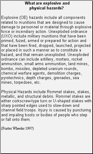 Although the likelihood of people being injured or killed by unexploded
ordnance materials, or Rommel stakes during routine daily activities is extremely
low, potential current and future hazards still exist and cannot be entirely
eliminated for people recreating in the downtown area. Surveys, screening, intrusive
sampling, and historical information reviews have been conducted on areas in
the downtown region to help establish the potential level of hazard for people
to come in contact with unexploded ordnance. The Navy has performed extensive
investigations and removal actions that will continue as part of the remedial
investigation process of Operable Unit B (OU-B). The Navy has determined that
the downtown area does not pose an unacceptable hazard level to people who live,
work, or play downtown. To reduce the likelihood of people to handle explosive
and physical hazards, the Navy initiated and continues to educate people on
the possible appearance of hazardous and explosive item and the procedure for
notifying the correct officials.
Although the likelihood of people being injured or killed by unexploded
ordnance materials, or Rommel stakes during routine daily activities is extremely
low, potential current and future hazards still exist and cannot be entirely
eliminated for people recreating in the downtown area. Surveys, screening, intrusive
sampling, and historical information reviews have been conducted on areas in
the downtown region to help establish the potential level of hazard for people
to come in contact with unexploded ordnance. The Navy has performed extensive
investigations and removal actions that will continue as part of the remedial
investigation process of Operable Unit B (OU-B). The Navy has determined that
the downtown area does not pose an unacceptable hazard level to people who live,
work, or play downtown. To reduce the likelihood of people to handle explosive
and physical hazards, the Navy initiated and continues to educate people on
the possible appearance of hazardous and explosive item and the procedure for
notifying the correct officials. Levels of contaminants including aluminum, arsenic, cadmium, chromium,
dieldrin, PCBs, and lead present in rock greenling, Pacific halibut,
Pacific cod, rock sole and blue mussels from the intertidal areas of Kuluk Bay
currently present no apparent public health hazard to recreational or subsistence
consumers and are not likely to result in adverse health effects.
Levels of contaminants including aluminum, arsenic, cadmium, chromium,
dieldrin, PCBs, and lead present in rock greenling, Pacific halibut,
Pacific cod, rock sole and blue mussels from the intertidal areas of Kuluk Bay
currently present no apparent public health hazard to recreational or subsistence
consumers and are not likely to result in adverse health effects. For most people who do not work with polychlorinated biphenyls (PCBs), consumption of PCB
contaminated fish, meats, eggs and dairy products are the most common and important sources of human
exposure to PCBs (ATSDR 2000b).
For most people who do not work with polychlorinated biphenyls (PCBs), consumption of PCB
contaminated fish, meats, eggs and dairy products are the most common and important sources of human
exposure to PCBs (ATSDR 2000b).