PUBLIC HEALTH ASSESSMENT
This Web site is provided by the Agency for Toxic Substances and Disease Registry (ATSDR) ONLY as an historical reference for the public health community. It is no longer being maintained and the data it contains may no longer be current and/or accurate.
Y-12 Uranium Releases
OAK RIDGE RESERVATION (USDOE)
OAK RIDGE, ANDERSON COUNTY, TENNESSEE
In 1942, the federal government established the Oak Ridge Reservation (ORR) in Anderson and Roane counties in Tennessee as part of the Manhattan Project to research, develop, and produce special nuclear materials for nuclear weapons. Four facilities were built at that time. The Y-12 plant, the K-25 site, and the S-50 site were created to enrich uranium. The X-10 site was created to demonstrate processes for producing and separating plutonium. Since the end of World War II, the role of the ORR (Y-12 plant, K-25 site, and X-10 site) broadened widely to include a variety of nuclear research and production projects vital to national security.
In 1989, the ORR was added to the U.S. Environmental Protection Agency's (EPA's) ![]() National Priorities List because, over the years, the ORR operations have generated
a variety of radioactive and nonradioactive wastes that are present in old waste
sites or have been released into the environment. The U.S. Department of Energy
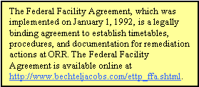
is conducting cleanup activities at the ORR under a Federal Facility Agreement
with EPA and the Tennessee Department of Environment and Conservation. These
agencies are working together to investigate and take remedial action on hazardous
waste from past and present activities at the site.
National Priorities List because, over the years, the ORR operations have generated
a variety of radioactive and nonradioactive wastes that are present in old waste
sites or have been released into the environment. The U.S. Department of Energy
is conducting cleanup activities at the ORR under a Federal Facility Agreement
with EPA and the Tennessee Department of Environment and Conservation. These
agencies are working together to investigate and take remedial action on hazardous
waste from past and present activities at the site.
For the last 10 years, the Agency for Toxic Substances and Disease Registry (ATSDR) has responded to requests and addressed health concerns of community members, civic organizations, and other government agencies by working extensively to determine whether levels of environmental contamination at and near the ORR present a public health hazard to communities surrounding the ORR. During this time, ATSDR has identified and evaluated several public health issues and has worked closely with many parties. ATSDR is the principal federal public health agency charged with evaluating human health effects of exposure to hazardous substances in the environment. While the Tennessee Department of Health (TDOH) conducted the Oak Ridge Health Studies to evaluate whether off-site populations have been exposed in the past, ATSDR's activities focused on current public health issues related to Superfund cleanup activities at the site. Prior to this public health assessment, ATSDR addressed current public health issues related to two off-site areas affected by ORR operations–the East Fork Poplar Creek area and the Watts Bar Reservoir area.
During Phase I and Phase II of the Oak Ridge Health Studies, the TDOH conducted extensive reviews and screening analyses of the available information and identified four hazardous substances that may have been responsible for adverse health effects: radionuclides from White Oak Creek, iodine, mercury, and polychlorinated biphenyls (PCBs). In addition to the dose reconstruction studies on these four substances, the TDOH conducted additional screening analyses for releases of uranium, radionuclides, and several other toxic substances.
To expand upon the efforts of the TDOH–not duplicate them–ATSDR scientists conducted a review and a screening analysis of the department's Phase I and Phase II screening-level evaluation of past exposure (1944-1990) to identify contaminants of concern for further evaluation. Based on this review, ATSDR scientists are conducting public health assessments on the release of iodine 131, Y-12 mercury releases, PCBs, radionuclides from White Oak Creek, Y-12 uranium releases, K-25 uranium and fluoride releases, and other topics such as the Toxic Substances Control Act (TSCA) incinerator and off-site groundwater. In conducting these public health assessments, ATSDR scientists are evaluating and analyzing the information, data, and findings from previous studies and investigations to assess the public health implications of past and current exposure. The public health assessment is the primary public health process ATSDR uses to:
ATSDR scientists will also conduct a screening analysis of all available environmental sampling data from 1990 to the present to determine whether additional contaminants of concern need to be addressed.
This public health assessment evaluates the releases of uranium from the Y-12 plant; assesses past and current uranium exposure to residents living near the ORR, including the residents of the Scarboro community (the reference community); addresses the community health concerns and issues associated with the uranium releases from the Y-12 plant; and, where possible, considers health outcome data that measure health effects associated with exposure to uranium or characterize the health status of a group of exposed people. This document does not address the release of other contaminants of concern such as mercury, iodine 131, PCBs, uranium from the K-25 facility, and fluorides, nor does it address exposures to those contaminants. ATSDR will evaluate these contaminants and other topics in separate public health assessments.
The 825-acre Y-12 plant, now called the Y-12 National Security Complex, is located in Bear Creek Valley and is bordered by Chestnut Ridge and Pine Ridge. The Y-12 plant was used in the 1940s to electromagnetically enrich uranium. In 1952, the facility was converted to enrich lithium-6 using a column-exchange process and to fabricate components for thermonuclear weapons using high-precision machining and other specialized processes. In 1992, after the Cold War ended, Y-12's mission was curtailed, and the plant is currently used for weapons disassembly and weapon renovation operations. The National Nuclear Security Administration currently uses the Y-12 National Security Complex as the primary storage site for highly enriched uranium. While operational levels have increased since 1992, the total operations have not approached the levels experienced before the 1990s.
The Y-12 plant is about 2 miles south of downtown Oak Ridge. It is separated from the main residential areas of Oak Ridge by Pine Ridge, a ridge that rises to about 300 feet above the valley floor. In 1942, the city of Oak Ridge was established for the 13,000 persons who were expected to work at the ORR. The population peaked at 75,000 in 1945 and decreased to 30,229 in 1950. Since 1959, when the city of Oak Ridge became self-governing, the Oak Ridge population has been approximately 27,000. The Scarboro community is a residential area within the city of Oak Ridge, about a half mile from the Y-12 plant, and is separated from the Y-12 plant by Pine Ridge. Scarboro was established in 1950 to provide single-family homes, duplexes, apartments, and an elementary school to African-American Oak Ridge residents. Scarboro remains predominantly African-American and has a population of approximately 300 persons.
The meteorological data indicates that the predominant wind directions at the Y-12 plant are southwest and northeast, generally up and down Bear Creek Valley, between Pine Ridge and Chestnut Ridge, with limited winds crossing over the ridges. Therefore, most of the uranium would deposit up and down Bear Creek Valley and Union Valley. No one lives in these valleys. The city of Oak Ridge is the only established community where people resided during the years of uranium releases that could have been impacted by Y-12 uranium releases. In this public health assessment, the Scarboro community is used as a reference location that represents the city of Oak Ridge.
During Phase II of the Oak Ridge Health Studies, the TDOH identified Scarboro as a reference location using air dispersion modeling to estimate average ground-level air concentrations at locations surrounding the reservation. According to the modeling results, Scarboro was the off-site population likely to receive the highest exposures to past releases from the Y-12 plant. The Task 6 report stated that "while other potentially exposed communities were considered in the selection process, the reference locations [Scarboro] represent residents who lived closest to the ORR facilities and would have received the highest exposures from past uranium releases...Scarboro is the most suitable for screening both a maximally and typically exposed individual."
Past Exposure
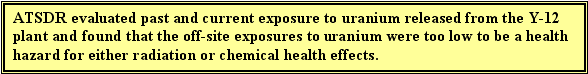
ATSDR evaluated both radiation and chemical aspects of past uranium exposure. ATSDR concluded that past off-site exposure to uranium from Y-12 is not a public health hazard. Neither the total radiation dose nor the chemical ingestion and inhalation doses from off-site exposure to uranium released from the Y-12 plant in the past would have caused harmful health effects.
To evaluate past exposure to uranium releases from the Y-12 plant, ATSDR primarily relied on data generated during Task 6 of the TDOH's Reports of the Oak Ridge Dose Reconstruction, Uranium Releases from the Oak Ridge Reservation–a Review of the Quality of Historical Effluent Monitoring Data and a Screening Evaluation of Potential Off-Site Exposures (referred to as the "Task 6 report"). The city of Oak Ridge is the only established community adjacent to ORR that could have been impacted by Y-12 uranium releases. The Scarboro community was selected as the reference population after air dispersion modeling indicated that its residents were expected to have received the highest exposures. The Scarboro community, located in the city of Oak Ridge, is a representative community; therefore, the conclusions are valid for the people living near the Y-12 Plant, including the city of Oak Ridge.
To evaluate cancer health effects from past radiation exposure, ATSDR adjusted the total uranium radiation doses reported in the Task 6 report to be equivalent to a 70-year exposure1. The total radiation dose received by the reference population, the Scarboro community, from all air, surface water, and soil exposure pathways (a committed effective dose [CEDE] of 155 millirem [mrem] over 70 years) is well below (32 times less than) the ATSDR radiogenic cancer comparison value of 5,000 mrem over 70 years. This radiogenic cancer comparison value assumes that the entire radiation dose (a 70-year dose, in this case) from the intake of uranium is received in the first year following the intake. Doses below this value are not expected to result in adverse health effects. Therefore, ATSDR does not expect carcinogenic health effects to have occurred from exposure to uranium in the past.
 To evaluate noncancer health effects from the total past uranium radiation
dose received by the Scarboro community (a CEDE of 155 mrem over 70 years),
ATSDR divided that dose by 70 years to approximate a value of 2.2 mrem as the
radiation dose for the first year. This approximate dose is well below (45 times
less than) the ATSDR minimum risk level (MRL) of 100 mrem/year for chronic ionizing
radiation exposure. ATSDR believes that the MRL itself is below levels that
might cause adverse health effects in people most sensitive to such effects,
and therefore does not expect noncancer health effects to have occurred from
radiation doses received from past Y-12 uranium releases.
To evaluate noncancer health effects from the total past uranium radiation
dose received by the Scarboro community (a CEDE of 155 mrem over 70 years),
ATSDR divided that dose by 70 years to approximate a value of 2.2 mrem as the
radiation dose for the first year. This approximate dose is well below (45 times
less than) the ATSDR minimum risk level (MRL) of 100 mrem/year for chronic ionizing
radiation exposure. ATSDR believes that the MRL itself is below levels that
might cause adverse health effects in people most sensitive to such effects,
and therefore does not expect noncancer health effects to have occurred from
radiation doses received from past Y-12 uranium releases.
 To evaluate potential chemical health effects from past uranium exposure, ATSDR
estimated exposure through the air pathway and compared the yearly air concentrations
in the Scarboro community to ATSDR's inhalation MRL for uranium. Yearly estimated
average air concentrations of uranium in Scarboro ranged from 2.1 × 10⁻⁸
to 6.0 × 10⁻⁵ milligrams per cubic meter (mg/m3).
These air concentrations are less than 1% of the inhalation MRL for chemical
effects (8 × 10⁻³ mg/m3). ATSDR also estimated exposure
to uranium through the soil and surface water pathways and compared the resulting
doses to levels associated with known health effects. Yearly estimated doses
from exposure to uranium via all soil ingestion and surface water exposure pathways
ranged from 2.7 × 10⁻⁵ to 1.3 × 10⁻² milligrams
per kilogram per day (mg/kg/day). All doses are less than the dose (5 ×
10-2 mg/kg/day) at which health effects (renal toxicity) have been
observed in rabbits, the mammalian species most sensitive to uranium kidney
toxicity. Therefore, ATSDR does not expect that residents were exposed in the
past to levels of uranium that would cause harmful chemical effects.
To evaluate potential chemical health effects from past uranium exposure, ATSDR
estimated exposure through the air pathway and compared the yearly air concentrations
in the Scarboro community to ATSDR's inhalation MRL for uranium. Yearly estimated
average air concentrations of uranium in Scarboro ranged from 2.1 × 10⁻⁸
to 6.0 × 10⁻⁵ milligrams per cubic meter (mg/m3).
These air concentrations are less than 1% of the inhalation MRL for chemical
effects (8 × 10⁻³ mg/m3). ATSDR also estimated exposure
to uranium through the soil and surface water pathways and compared the resulting
doses to levels associated with known health effects. Yearly estimated doses
from exposure to uranium via all soil ingestion and surface water exposure pathways
ranged from 2.7 × 10⁻⁵ to 1.3 × 10⁻² milligrams
per kilogram per day (mg/kg/day). All doses are less than the dose (5 ×
10-2 mg/kg/day) at which health effects (renal toxicity) have been
observed in rabbits, the mammalian species most sensitive to uranium kidney
toxicity. Therefore, ATSDR does not expect that residents were exposed in the
past to levels of uranium that would cause harmful chemical effects.
Additionally, it should be noted that several levels of conservatism were built into this evaluation of past exposures. The values that ATSDR relied on to evaluate past exposures (those from the Task 6 report) came from a screening evaluation that routinely and appropriately used conservative and protective assumptions and approaches. This led to an overestimation of concentrations and doses. Even using these conservative overestimations of concentrations and doses, persons in the reference community (Scarboro) and other communities near the Y-12 plant were exposed to levels of uranium that are below health concern.
Current Exposure
ATSDR evaluated both radiation and chemical aspects of current uranium exposure. Based on our review of data collected in and around the Scarboro community, and as compared to background and distant areas, ATSDR has determined that exposure to the current levels of uranium would not cause harmful health effects.
To assess current exposure to uranium releases from the Y-12 plant, ATSDR evaluated air data from monitoring stations, surface water sampling from East Fork Poplar Creek and Scarboro, recent soil sampling from the Scarboro community, samples of garden crops from Scarboro, and garden crop samples from outlying areas. Most of the data were supplied by the Oak Ridge Environmental Information System (OREIS), a centralized, standardized, quality-assured, and configuration-controlled environmental data management system that is publicly available. ATSDR also supplemented the evaluation with data from the Scarboro Community Environmental Study by the Florida Agricultural and Mechanical University (FAMU) and the September 2001 Sampling Report for the Scarboro Community by EPA. ATSDR evaluated the following pathways: ingestion of soil, ingestion of foods, ingestion of water from nearby creeks, inhalation of air, and external exposure from uranium in soils.
To evaluate the cancer effects of current exposure to radiation from uranium, ATSDR assessed the radiation dose received by the reference population–the Scarboro community–through exposure to uranium ingested in soil and vegetables and inhaled in air. That dose (0.216 mrem) is well below (23,000 times less than) the radiogenic cancer comparison value of 5,000 mrem over 70 years. ATSDR derived this CEDE from the intake of uranium, making the assumption that the entire dose (a 70-year dose, in this case) is received in the first year following the intake. Doses below this value are not expected to have adverse health effects. Therefore, ATSDR does not expect harmful radiation effects to occur from the exposure to uranium that is occurring currently.
ATSDR also evaluated noncancer health effects from the total current uranium radiation dose (a CEDE of 0.216 mrem over 70 years) received by the Scarboro community, ATSDR divided the CEDE of 0.216 mrem, which is based on 70 years of exposure, by 70 years to approximate a value of 0.003 mrem as the radiation dose for the first year. This approximate dose of 0.003 mrem is well below (33,000 times lower than) the ATSDR minimum risk level (MRL) of 100 mrem/year for chronic ionizing radiation exposure. ATSDR believes the chronic ionizing radiation received by communities near the Y-12 plant from uranium exposure is below levels that might cause adverse health effects in people most sensitive to such effects, and therefore does not expect noncancer health effects to occur from current radiation doses.
In addition, ATSDR compared the soil radioactivity concentrations in the reference location (Scarboro) with typical concentrations found in nature and from background samples collected from uncontaminated areas around the reservation. This evaluation showed that the soil radioactivity concentrations in Scarboro were indistinguishable from natural and background concentrations.
To evaluate potential chemical health effects, ATSDR estimated exposure through the air pathway and compared the yearly air concentrations in the Scarboro community to ATSDR's inhalation MRL. Average uranium air concentrations from monitoring stations near the ORR (ranging from 3.7 × 10⁻¹¹ to 1.4 × 10⁻¹⁰ mg/m3), including station 46 in Scarboro (5.4 × 10⁻¹¹), are several orders of magnitude below (over a million times less than) the intermediate-duration MRL of 8 × 10⁻³ mg/m3 for insoluble forms of uranium. ATSDR also estimated exposure to uranium through the soil and surface water pathways and compared the resulting doses to ATSDR's screening values: the environmental media evaluation guide (EMEG) and the oral MRL. The concentrations of uranium found in the surface water from off-site areas of East Fork Poplar Creek (0.197 and 12.8 micrograms per liter, or µg/L) are below ATSDR's EMEG of 20 µg/L. Additionally, the estimated doses from ingestion of uranium in soil (ranging from 2.07 × 10⁻⁶ to 1.4 × 10⁻⁵ mg/kg/day) and food (3.0 × 10⁻⁵ and 3.9 × 10⁻⁵ mg/kg/day in the Scarboro community) were well below the oral MRL of 2 × 10⁻³ mg/kg/day. Even if the exposures from the two pathways are combined, the resulting dose is still lower than the MRL. For example, if the highest dose following ingestion of soil is added to the total intake from ingestion of vegetables grown in Scarboro, the total ingestion dose is 5.3 × 10⁻⁵ mg/kg/day, which is about two orders of magnitude below the MRL. Therefore, ATSDR believes that residents are currently being exposed to levels of uranium that would not cause harmful chemical effects.
In 1942, the federal government established the 58,000-acre Oak Ridge Reservation (ORR), located in Anderson and Roane counties in Tennessee, as part of the Manhattan Project to research, develop, and produce special nuclear materials for nuclear weapons (ChemRisk 1993a; TDOH 2000). Four facilities were built. The Y-12 plant, the K-25 site, and the S-50 site were created to enrich uranium (U), and the X-10 site was created to demonstrate processes for producing and separating plutonium (TDOH 2000)2. The Clinch River forms the southern and western boundaries of the reservation, and most of the property is within the Oak Ridge city limits (EUWG 1998). Please see Figure 1 for the location of the ORR.
The Y-12 plant is located in the eastern end of Bear Creek Valley. It is bordered on the south by Chestnut Ridge and on the north by Bear Creek Road and Pine Ridge (ChemRisk 1999). The main Y-12 production area is about 0.6 miles wide and 3.2 miles long; the area contains roughly 240 principal buildings, of which about 18 were directly involved with processing and/or storage of uranium compounds (Patton 1963; UCC-ND 1983 as cited in ChemRisk 1999). The 825-acre Y-12 plant is located within the corporate limits of the city of Oak Ridge, about 2 miles south of downtown (ChemRisk 1999). It is less than a half mile from the Scarboro community, but Pine Ridge (which rises to about 300 feet above the valley floor) separates the Y-12 plant from the main residential areas of Oak Ridge (TDOH 2000).
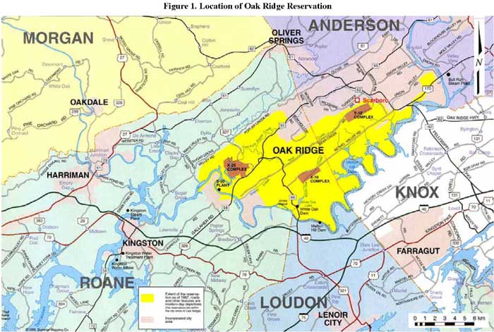
Figure 1. Location of Oak Ridge Reservation
Since the early 1940s, the ORR processed large quantities of uranium, enriching it into uranium 235 for the production of nuclear weapon components and for use in commercial nuclear reactors and various research and development projects (ChemRisk 1993a as cited in ChemRisk 1999).
From 1944 to 1947, the Y-12 plant was used to electromagnetically enrich uranium, but in 1952 the facilities were converted to fabricate nuclear weapon components (ChemRisk 1999). During the Cold War, a column-exchange process (Colex) that used large quantities of mercury as an extraction solvent to enrich lithium in lithium 6 was built and operated (TDOH 2000). At the end of the Cold War, the Y-12 missions were curtailed. In 1992 the major focus of the Y-12 plant was the remanufacture of nuclear weapon components and the dismantlement and storage of strategic nuclear materials from retired nuclear weapons systems. In October 2000, oversight of the Y-12 plant was changed from the U.S. Department of Energy (DOE) Oak Ridge Operations to the DOE National Nuclear Security Administration. The National Nuclear Security Administration currently uses the Y-12 National Security Complex as the primary storage site for highly enriched uranium. While operational levels have increased since 1992, the total operations have not approached the levels experienced prior to the 1990s. See Figure 2 for a time line of the major processes at the Y-12 plant.
Task 6 of the reports of the Oak Ridge Dose Reconstruction (ChemRisk 1999) gives greater detail on the operational history of the Y-12 plant. The key processes and activities associated with uranium include (1) feed preparation for enrichment operations (1943-1947), (2) electromagnetic enrichment (1943-1947), (3) uranium recovery and recycling operations (1944-1951), (4) uranium salvage operations (1947-1951), (5) uranium preparation and recycling for weapons component operations (1949-1995), (6) uranium forming and machining for weapon component operations (1949-1995, continuing to the present), and (7) weapons component assembly operations (1952-1995, continuing to the present) (ChemRisk 1999). For more details, please see Section 1.4 and Appendix A of Task 6 of the Reports of the Oak Ridge Dose Reconstruction, Uranium Releases From the Oak Ridge Reservation–A Review of the Quality of Historical Effluent Monitoring Data and a Screening Evaluation of Potential Off-Site Exposures (ChemRisk 1999) (referred to as the "Task 6 report") and the Oak Ridge Health Studies Phase 1 Report: Volume II–Part A–Dose Reconstruction Feasibility Study, Tasks 1 & 2, A Summary of Historical Activities on the Oak Ridge Reservation With Emphasis on Information Concerning Off-Site Emission of Hazardous Material (ChemRisk 1993a).
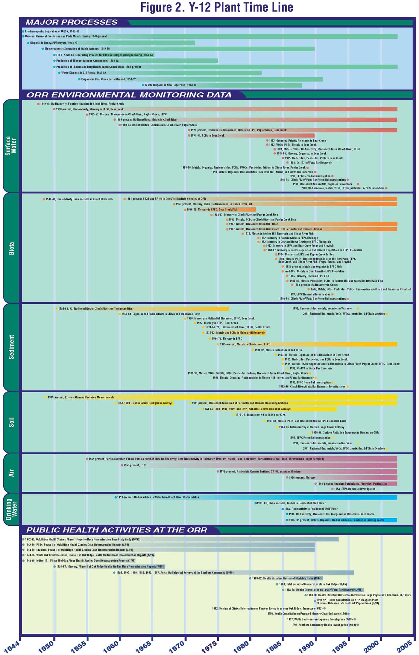
Figure 2. Y-12 Facility Time Line
II.C. Remedial and Regulatory History
 Because
ORR operations have generated a variety of radioactive and nonradioactive wastes,
the ORR was added to the National Priorities List (NPL) in 1989 (EPA 2002b).
DOE is conducting cleanup activities at the ORR under a Federal Facility Agreement,
which is an Interagency Agreement with the U.S. Environmental Protection Agency
(EPA) and the Tennessee Department of Environment and Conservation (TDEC). This
agreement allows for input from the public. These parties are working together
to investigate and take remedial action on hazardous waste from past and present
activities at the site. DOE is integrating required measures from the Resource
Conservation and Recovery Act (RCRA) with response actions under the Comprehensive
Environmental Response, Compensation, and Liability Act (CERCLA). See Figure
2 for a time line of surface water, biota
Because
ORR operations have generated a variety of radioactive and nonradioactive wastes,
the ORR was added to the National Priorities List (NPL) in 1989 (EPA 2002b).
DOE is conducting cleanup activities at the ORR under a Federal Facility Agreement,
which is an Interagency Agreement with the U.S. Environmental Protection Agency
(EPA) and the Tennessee Department of Environment and Conservation (TDEC). This
agreement allows for input from the public. These parties are working together
to investigate and take remedial action on hazardous waste from past and present
activities at the site. DOE is integrating required measures from the Resource
Conservation and Recovery Act (RCRA) with response actions under the Comprehensive
Environmental Response, Compensation, and Liability Act (CERCLA). See Figure
2 for a time line of surface water, biota ![]() , sediment, soil, air, and drinking
water environmental monitoring data related to activities at the Y-12 plant.
, sediment, soil, air, and drinking
water environmental monitoring data related to activities at the Y-12 plant.
Contaminants such as uranium and mercury are present in old waste sites, which occupy 5% to 10% of the ORR. The abundant rainfall (an annual average of 55 inches) and high water tables (for example, 0 to 20 feet below the surface) on the reservation contribute to leaching of these contaminants, resulting in contaminated soil, surface water, sediments, and groundwater (EUWG 1998).
Since 1986 (when initial cleanup activities commenced), DOE has initiated approximately 50 response actions under the Federal Facility Agreement that address contamination and disposal issues on the reservation. In order to consolidate investigation and remediation of environmental contamination, the contaminated areas were divided into five large tracts of land, generally associated with the major hydrologic watersheds (EUWG 1998). The following remedial actions pertain to the Y-12 plant specifically:
Further detailed information on remedial and regulatory information at the ORR can be found in Oak Ridge Health Studies Phase 1 Report: Volume II–Part A–Dose Reconstruction Feasibility Study, Tasks 1 & 2, A Summary of Historical Activities on the Oak Ridge Reservation With Emphasis on Information Concerning Off-Site Emission of Hazardous Material (ChemRisk 1993a); Public Involvement Plan for CERCLA Activities at the U.S. Department of Energy, Oak Ridge Reservation (C.J. Enterprises 2001); and Oak Ridge Reservation Annual Site Reports.
II.D. Land Use and Natural Resources
The ORR currently has about 35,000 acres. The three major DOE installations–the East Tennessee Technology Park (formerly the K-25 site and the Oak Ridge Gaseous Diffusion Plant), Oak Ridge National Laboratory (formerly the X-10 site), and the Y-12 National Security Complex (formerly the Y-12 plant)–occupy about 30% of that acreage. The remaining 70% was established as a National Environmental Research Park in 1980, to provide protected land for environmental science research and education and to demonstrate that energy technology development can coexist with a quality environment. Large portions of the reservation, much of which had formerly been cleared for farmland, have grown into full forests over the past several decades. Some of this land includes areas known as "deep forest" that contain ecologically significant flora and fauna; portions of ORR are considered to be biologically rich (SAIC 2002).
The ORR also included an area set aside for residential, commercial, and support services. The city of Oak Ridge was created in 1942 to provide housing to the employees of ORR and was originally controlled by the military (Friday and Turner 2001). The self-governing portion of the city of Oak Ridge comprises about 14,000 acres and contains housing, schools, parks, shops, offices, and industrial areas. The urban population of Oak Ridge continued to grow over several decades, and some residential properties are next to the ORR boundary line. Outside the urban areas, much of the region (about 40%) is still a pattern of farms and small communities, as it was historically (ChemRisk 1993c).
Public access is restricted at the Y-12 plant, which is located entirely within the ORR "229 Boundary." Y-12 is "an active production and special nuclear materials management facility [and so] additional security and access limitations apply" (DOE 2002b). Out of 1,170 acres in the Upper EFPC area, 800 acres are currently used for industrial purposes. This area includes maintenance facilities, office space, training facilities, change houses, facilities that were formerly used by the Oak Ridge National Laboratory Biology Division, waste management facilities, construction contractor support areas, and a high-security portion that supports core National Nuclear Security Administration missions (DOE 2002b).
A number of maps of this area indicate a wide range of land types, including "types of urban or built up land, agricultural land, rangeland, forestland, water, and wetlands," and uses that consist of "residential, commercial, public and semi-public, industrial, transportation, communication and utility, and extractive (e.g., mining)" (ChemRisk 1993c).
Agriculture (beef and dairy cattle) and forestry had been the two predominant land uses in the area around ORR; however, both of these uses are currently declining. For many years, milk was produced, bottled, and distributed locally. Corn, tobacco, wheat, and soybeans were the major crops grown in the area. Small game and waterfowl are hunted in the area continuously, and deer are hunted during certain periods (ChemRisk 1993c). Radiological monitoring is performed during the annual deer hunts to "provide assurance that harvested animals do not contain levels of radionuclides which would result in significant internal exposure to humans consuming meat from the animals" (Teasley 1995).
EFPC originates from within the Y-12 plant boundary, flows through the city of Oak Ridge for about 12 miles, and ultimately converges with Poplar Creek near the K-25 facility (DOE 1989). A number of small tributaries flow into the creek and support some small aquatic life. EFPC is classified by the state of Tennessee as appropriate for fishing, recreation, irrigation, livestock watering, and wildlife use (ATSDR 1993a). While people do not use the streams on the reservation, public access exists downstream from the reservation. The area that Lower EFPC flows through has many uses, which can be grouped into five categories: residential, commercial, agricultural, other, and DOE-owned (DOE 1995a). The creek appears to be too shallow for swimming, although some areas, particularly those near the confluence with Poplar Creek, are suitable for wading and fishing. TDEC issued a fishing advisory for EFPC that warns the public to avoid eating fish from the creek and to avoid contact with the water (ATSDR 1993a).
Groundwater is contaminated throughout much of the on-site Upper EFPC area. No one, however, is currently using the groundwater in the area where a contaminated groundwater plume extends past the ORR boundary (i.e., in Union Valley to the east of ORR) (DOE 2002b). The shallow groundwater along some off-site areas of the Lower EFPC floodplain contains metals at levels of public health concern; however, this off-site shallow groundwater is not used for drinking or other domestic purposes.
II.E.1. Oak Ridge
The city of Oak Ridge, Tennessee, was established in Anderson County in 1942, for the 13,000 persons who were expected to work at the ORR (Friday and Turner 2001). By July 1944, the population of Oak Ridge had increased to 50,000. The population peaked at 75,000 in 1945 and decreased to 30,229 by 1950 (see Table 1) (Oak Ridge Comprehensive Plan 1988). In 1959, about 14,000 acres within the city of Oak Ridge became self-governing (ChemRisk 1993c). Almost since its establishment, the city of Oak Ridge has been the largest population center in the area (ChemRisk 1993c).
Table 1. Population of Oak Ridge From 1942 to 2000
| 1942 | 1944 | 1945 | 1950 | 1960 | 1970 | 1980 | 1990 | 2000 | |
| Oak Ridge | 13,000 | 50,000 | 75,000 | 30,229 | 27,169 | 28,319 | 27,662 | 27,310 | 27,387 |
Sources: ChemRisk 1993c; Oak Ridge Comprehensive Plan 1988; U.S. Census Bureau 2000
From 1940 to 1960, the city of Oak Ridge had a higher proportion of working-age people and fewer seniors than the rest of Tennessee (ChemRisk 1993c). However, since 1960, the population of residents over age 35 and over age 55 has increased, while the population of children under age 16 has declined (Oak Ridge Comprehensive Plan 1988). The education level of Oak Ridge citizens is dramatically higher than in surrounding areas; Oak Ridge boasts one of the highest per capita ratios of Doctors of Philosophy (Ph.D.s) of any city in the United States (Oak Ridge Comprehensive Plan 1988).
II.E.2. Scarboro
The Scarboro community is located within the city of Oak Ridge, about a half mile from the Y-12 plant, and is separated from the Y-12 plant by Pine Ridge. Before 1950, the area was known as the Gamble Valley Trailer Camp, and the population was predominantly white. In 1950, Scarboro was established to provide single-family homes, duplexes, apartments, and an elementary school to African-American Oak Ridge residents (Friday and Turner 2001). To this day, Scarboro remains predominantly African-American (94%) (Joint Center Summary Number 4).
In the fall of 1999, the Joint Center for Political and Economic Studies conducted a survey of the broader Scarboro community (Friday and Turner 2001). The staff identified 380 residences, of which 326 were occupied, and about 266 persons responded to the survey (82%). The report generated from the survey is one of the few sources of detailed information available on the Scarboro community (Friday and Turner 2001). Some of the demographic information resulting from this survey is presented in the following paragraphs. For additional details, please see the Scarboro Community Assessment Report (Friday and Turner 2001).
The Scarboro community is aging: the average respondent is almost 53 years old and only 36% of participating households reported having at least one member between the ages of 18 and 34 years old. About half of the households reported having one senior citizen or more, while only 23% of the surveyed households reported having children. Additionally, 39% of respondents were retired. As of 1999, the average length of residence in Scarboro was 29 years. However, many (82%) of the young adult residents (18-30 years old) moved to Scarboro after 1994 (Friday and Turner 2001).
Figure 3 provides the current demographics for a 1-mile and 3-mile radius of the Y-12 plant.
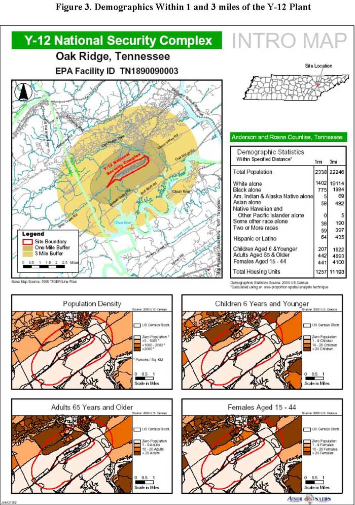
Figure 3. Demographics Within 1 and 3 miles of the Y-12 Plant
II.F. Summary of Public Health Activities Pertaining to Y-12 Uranium Releases
This section describes the public health activities that pertain to Y-12 uranium releases. Several additional public health activities that have been conducted at the ORR by ATSDR, the Tennessee Department of Health (TDOH), and other agencies are described in Appendix B. See Figure 2 for a time line of public health activities related to the Y-12 plant.
For the last 10 years, ATSDR has addressed the health concerns of community members, civic organizations, and other government agencies by working extensively to determine whether levels of environmental contamination at and near the ORR present a public health hazard. During this time, ATSDR has identified and evaluated several public health issues and has worked closely with many parties, including community members, civic organizations, physicians, and several local, state, and federal environmental and health agencies. While the TDOH conducted the Oak Ridge Health Studies to evaluate whether off-site populations have experienced exposures in the past, ATSDR's activities focused on current public health issues to prevent duplication of the state's efforts. The following paragraphs highlight major public health activities conducted by ATSDR that pertain to Y-12 uranium releases.
Figure 4 shows the organizational structure of the ORRHES and Figure 5 graphically demonstrates ways for the public to provide input into the ATSDR public health assessment process. For more information on the ORRHES, visit the ORRHES Web site at http://www.atsdr.cdc.gov/HAC/oakridge/index.html.
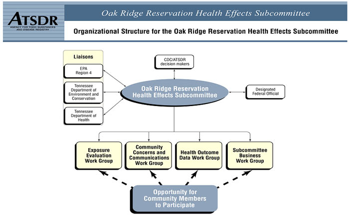
Figure 4. Organizational Structure for the Oak Ridge Reservation Health Effects Subcommittee
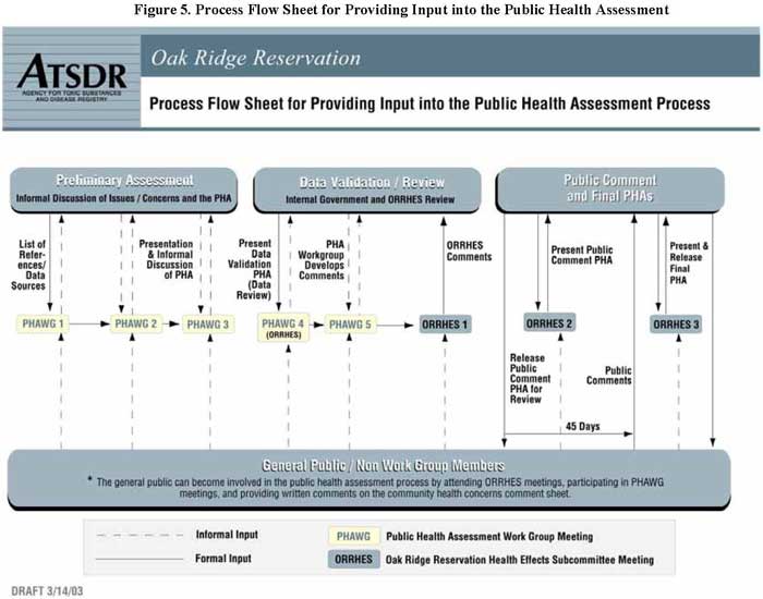
Figure 5. Process Flow Sheet for Providing Input into the Public Health Assessment
II.F.2. TDOH
Oak Ridge Health Studies. In 1991, DOE and the state of Tennessee entered into the Tennessee Oversight Agreement, which allowed the TDOH to undertake a two-phase independent state research project to determine whether past environmental releases from ORR operations harmed people who lived nearby (ORHASP 1999).
The findings of the Phase I Dose Reconstruction Feasibility Study indicated that a significant amount of information was available to reconstruct the past releases and potential off-site exposure doses for four hazardous substances that may have been responsible for adverse health effects. These four substances include (1) radioactive iodine releases associated with radioactive lanthanum processing at X-10 from 1944 through 1956; (2) mercury releases associated with lithium separation and enrichment operations at the Y-12 plant from 1955 through 1963; (3) PCBs in fish from EFPC, the Clinch River, and the Watts Bar Reservoir; and (4) radionuclides from White Oak Creek associated with various chemical separation activities at X-10 from 1943 through the 1960s.
 The study evaluated mercury releases associated with lithium separation and
enrichment operations at the Y-12 plant from 1955 through 1963. Results indicate
that depending on their activities, individuals living in the area during the
years that mercury releases were highest (mid-1950s to early 1960s) may have
received annual average doses of mercury exceeding the EPA reference dose.
The study evaluated mercury releases associated with lithium separation and
enrichment operations at the Y-12 plant from 1955 through 1963. Results indicate
that depending on their activities, individuals living in the area during the
years that mercury releases were highest (mid-1950s to early 1960s) may have
received annual average doses of mercury exceeding the EPA reference dose.Aerial Radiological Surveys and ORR Off-site Background. DOE and its predecessors on the ORR site and its immediate surroundings have performed aerial radiological surveys since 1959 and through to 1997, with increasing sophistication, as the methodology and detection capabilities have improved. Briefly, the present methodology is to calibrate during flight the aircraft-mounted instruments against a known radiation source, then survey the intended target area. The surveys are carried out at a constant airspeed and altitude. Any detected radiation sources are then investigated on the ground by standard survey techniques.
Around the ORR, including the Scarboro community, most of the "new" radiation sources are single-contour anomalies that show no elevated ground level readings. A single contour is defined as radiation that is limited in its area; that is, only a spot of radiation with no additional radiation detected at decreasing levels radiating from the central spot. If elevated readings within this single contour are found, the source of the radiation is determined. By this method, an inventory of known "off-site" radiation sources is established and maintained. They are included as "regions of interest" on the published radiation contour maps of the Oak Ridge area. They include such locations as the Atomic City Auto Parts, the CXS Railroad bed, and others related to past or current nuclear operations, as well as the Bull Run Steam plant where flyash from operations is stored (Maurer 1989).
The Chattanooga shale outcroppings containing elevated concentrations of uranium and its decay products occurring on East Fork Ridge and a few small cesium 137 deposits along the Clinch River during low water levels are both found by aerial survey. The Clinch River deposits have been studied by TDEC/Oak Ridge Operations (ORO) and deemed to be a non-hazard (Storms and Rector 1997).
Furthermore, the aerial surveys are sufficiently sensitive to detect sources that do not constitute a hazard. By implication, the aerial surveys will readily detect sources that do constitute a hazard. Except for a known few locations due to past or present operations, the off-site areas of Bear Creek and Union valleys, including residential areas of Oak Ridge, do not show any elevations of radiation above background. Thus, there is direct empirical evidence that the Union valley and Oak Ridge neighborhoods have not been contaminated.
Scarboro Community Health Investigation. In November 1997, a Nashville newspaper published an article about illnesses among children living near the nuclear weapons facility at the ORR in eastern Tennessee. The article described a high rate of respiratory illness among residents of the nearby community of Scarboro; it told of 16 children who had repeated episodes of "severe ear, nose, throat, stomach, and respiratory illnesses." Among those respiratory illnesses were asthma, bronchitis, sinusitis, allergic rhinitis, and otitis media. The article implied that exposure to the ORR caused these illnesses especially given the proximity of these children's residences to ORR facilities. In response to this article, the Commissioner of the TDOH asked the CDC to work with the department to investigate the situation in Scarboro. The Scarboro Community Health Investigation, which included a community health survey and a follow-up medical evaluation of children under 18 years of age, was coordinated by TDOH to investigate a reported excess of respiratory illness among children in the Scarboro community. This investigation, both the survey and the examination components, was mainly designed to measure the rates of common respiratory illnesses among children who reside in Scarboro, compare these rates with national rates, and to determine if there were any unusual characteristics of these illnesses. The investigation was not designed to find what caused the illnesses.
In 1998, a study protocol was developed and a community health survey was administered to the members of each household in the community. The purpose of the survey was to determine whether the rates of certain diseases were higher in Scarboro than elsewhere in the United States and to determine whether exposure to various factors increased residents' risk for health problems. In addition, information regarding occupations, occupational exposures, and general health concerns was collected for adults. The participation/response rate of the health investigation survey was 83% (220/264 households) and included 119 questionnaires about children living in these households and 358 questionnaires about adults. In September 1998, CDC released the preliminary results of the survey. The asthma rate was 13% among children in Scarboro, compared to national estimates of 7% among all children aged 0-18 years and 9% among African-American children aged 0-18 years. The Scarboro rate was, however, within the range of rates from 6% to 16% reported in similar studies throughout the United States. The wheezing rate among children in Scarboro was 35%, compared to international estimates that range from 1.6% to 36.8%. With the exception of unvented gas stoves, no statistically significant association was found between exposure to common environmental triggers of asthma (that is, pests, environmental tobacco smoke, and the presence of dogs or cats in the home) or potential occupational exposures (such as living with an adult who works at the ORR or living with an adult who works with dust and fumes and brings exposed clothes home for laundering), and asthma or wheezing illness.
Based on the information obtained in the health investigation survey, 36 children, including those identified in the media report, were invited to receive a physical examination. These examinations were conducted in November and December 1998 to confirm the results of the community survey, to determine whether children with respiratory illnesses were getting the medical care they needed, and to determine whether the children reported in the newspaper to have respiratory medical problems really had these problems. Children who were invited to participate met one or more conditions: (1) severe asthma, defined as more than 3 episodes of wheezing or visiting an emergency room because of these symptoms; (2) severe undiagnosed respiratory illness, defined as more than 3 episodes of wheezing and visiting an emergency room because of these symptoms; (3) respiratory illness and no regular source of medical care; or (4) identified as having respiratory illness in newspaper reports. Of the 36 children invited, 23 participated in the physical examination. Some of the eligible 36 children had moved out of Scarboro; others either were not available or decided not to participate.
During the physical examination, nurses asked children who participated and their parents a series of questions about the health of the child; volunteer pediatricians reviewed the results of the nurse interview and examined the children. In addition to direct physical examinations, children also underwent a blood test and a special breathing test. If the examining doctor thought the child needed an x-ray to complete the assessment, this was done. All examinations, tests, and transportation to and from Knoxville were provided free of charge.
Immediately after the examinations, the results were reviewed and none of the children had findings that needed immediate intervention. A number of laboratory tests were found to be either above or below the normal range, such as blood calcium level, blood hemoglobin level, or breathing test abnormality. Following the initial review of results, laboratory results were communicated by letter or telephone to the parents of the children and their doctors. If the parents did not want the results sent to a doctor, the results were given to the parents by telephone. The parents of children with any health concern identified as a result of the examination were sent a personal letter from Paul Erwin, M.D., of the East Tennessee Regional Office of the TDOH, informing them of the need for follow-up with their medical provider. If they did not have a medical provider, they were to contact Brenda Vowell, RNC, Public Health Nurse, East Tennessee Regional Office of the TDOH, for help in finding a provider and possible TennCare or Children's Special Service.
In January 1999, a team of physicians representing CDC, TDOH, the Oak Ridge medical community, and the Morehouse School of Medicine, thoroughly reviewed the findings of the physical examinations and the community survey. Of the 23 children who were examined, 22 had evidence of some form of respiratory illness (reported during the nurse interview or discovered during the doctor's examination). Overall, the children appeared healthy and no problems that needed urgent management were identified. Several children had mild respiratory illnesses at the time of the examination; only one child had findings of an abnormality of the lungs at the time of the examination. None of the children had wheezing. The examinations did not indicate any unusual pattern of illness among children in Scarboro. The illnesses that were detected were not more severe than would be expected and were typical of those that might be found in any community. The findings of examinations essentially confirmed the results of the community health survey. The results of the review were presented on January 7, 1999, at a community meeting in Scarboro. The final report was released in July 2000. A brief summarizing this report is provided in Appendix I.
Three months after the letters went to the parents and physicians about the findings, attempts were made to telephone the parents of children who participated. Eight parents were successfully contacted. Because some of the parents had more than one child who was examined, questions addressed the health of 14 children. Parents of nine children could not be contacted despite attempts on several days to contact them by telephone.
Of the 14 children whose parents had been contacted, 7 had seen a doctor since the examinations. In most cases, the health of the child was the about the same, although one child had been hospitalized because of asthma, and another child's asthma medication had been increased to treat worsening asthma. Several children had nasal allergies, and several parents mentioned difficulties in obtaining medicines because of cost and lack of coverage by TennCare for the particular medicines. Health department nurses subsequently have assisted these parents in getting the needed medicines.
Scarboro Community Environmental Study. In 1998, soil, sediment, and surface water were sampled in the Scarboro community to address community concerns about environmental monitoring in the Scarboro neighborhood (see Figure 6 for sample locations). The analytical component of the study was conducted by the Environmental Sciences Institute at Florida Agricultural and Mechanical University (FAMU) and its contractual partners at the Environmental Radioactivity Measurement Facility at Florida State University and the Bureau of Laboratories of the Florida Department of Environmental Protection, and by DOE subcontractors in the Neutron Activation Analysis Group at the Oak Ridge National Laboratory. All samples were analyzed for mercury, gross alpha/beta content, uranium, and gamma emitting radionuclides. About 10% of the samples were also analyzed for target compound list organics, target analyte list inorganics, strontium 90, uranium, thorium, and plutonium.
Organic compounds were only detected in one of the samples tested. This same sample also contained lead and zinc at concentrations twice as high as that found in the Background Soil Characterization Project (DOE 1993). Mercury was found within the range given in the Background Soil Characterization Project, and about 10% of the soil samples showed evidence of enrichment in uranium 235. The final Scarboro Community Environmental Study was released in September 22, 1998, during a Scarboro community meeting (FAMU 1998). A brief summarizing this report is provided in Appendix I.
Scarboro Community Environmental Sampling Validation Study. In 2001, EPA's Science and Ecosystem Division Enforcement Investigation Branch collected soil, sediment, and surface water samples from the Scarboro community to respond to community concerns, identify data gaps, and validate the sampling performed by FAMU in 1998 (FAMU 1998) (see Figure 6 for sample locations). All samples were subjected to a full analytical scan, including inorganic metals, volatile organic compounds, semi-volatile organic compounds, radiochemicals, organochlorine pesticides, and PCBs. In addition, EPA collected uranium core samples from two locations in Scarboro and conducted a radiation walkover of the areas selected for sampling to determine whether radiation existed above background levels.
The level of radiation was below background levels and the radionuclide analytical values did not indicate a level of health concern. Uranium levels in the core soil samples were also below background levels. EPA concluded that the results support the sampling performed by FAMU in 1998, and that there is not an elevation of chemical, metal, or radionuclides above a regulatory health level of concern. The residents of Scarboro are not currently being exposed to harmful levels of substances from the Y-12 plant. The report stated that "based on EPA's results, the Scarboro community is safe. Therefore, additional sampling to determine current exposure is not warranted." A final report was released in April 2003 (EPA 2003). A brief summarizing this report is provided in Appendix I.
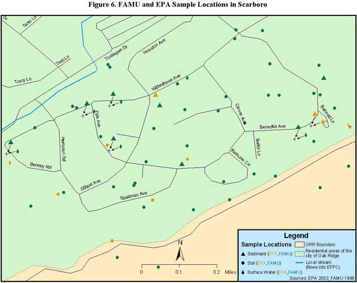
Figure 6. FAMU and EPA Sample Locations in Scarboro
Next Section Table
of Contents