Element 5: Potentially Exposed Populations
This section discusses the last element in the exposure pathway evaluation. It describes how to characterize and estimate the number of people in the potentially exposed populations for a site.
A primary component of any exposure pathway evaluation is identifying the specific populations who come into contact with site-related contaminants (in the past, present, or future). Health assessors need to evaluate the characteristics and size of the potentially exposed population, as well as consider the population’s activities and other factors that could influence the extent of possible past, current, and future exposures. Health assessors should identify potentially exposed populations as specifically and accurately as possible.
Populations to Consider
- Residents
- Those engaged in recreational activities
- Seasonal or temporary residents
- Potential “high risk” populations, including pregnant women and developing children
- Uniquely vulnerable populations
- Workers
Examples of Exposed Populations
| Exposure Pathway | Population of Concern |
|---|---|
| Contaminated soil in a residential area along the border of a site. | 
CDC/Dawn Arlotta; photographer: Cade Martin Residents living in that area and those who frequent the area. |
| Contaminated sediment in a local pond. | 
Recreational users of the pond. |
| Water within a private well. | 
Users of the private well water. |
Characterizing Potentially Exposed Populations
Each site is unique and must be considered individually to determine factors that could enhance or hinder the frequency, duration, and magnitude of human exposure. A thorough analysis identifies past, present, and potential future exposed populations and the extent of exposures via different exposure pathways.
Exposure potential across populations at a site can vary dramatically. Be as detailed as possible about the extent to which a given population might come in contact with a contaminated environmental medium.
A review of land and natural resource use at or near the site will provide valuable information about the activities of the surrounding population and the probability for human exposure. Land use significantly affects the types and frequency of human activities, thereby affecting the degree and intensity of human contact with water, soil, air, exposed wastes, or consumable plants and animals. Site access and use (e.g., playing, swimming, hunting, fishing) also need to be examined carefully. This kind of information can be obtained from observations during the site visit, in site reports and other documentation, and through conversations with stakeholders, including community members, state, local, and tribal officials, and responsible parties and their representatives (e.g., environmental consultants).
Key Questions to Ask When Characterizing Potentially Exposed Populations
- Who is exposed?
- What activities are occurring?
- Where are activities occurring?
- When has exposure occurred (past, current, future)? For how long?
- How are people exposed? How is the land used? Are there any unique exposures?
Potentially Exposed Populations: Why “potentially”?
Remember, the presence of a population in the site vicinity does not mean exposure has occurred, is occurring, or will occur. It is your job to determine who, if anyone, might come in contact with contaminated media. The more specifically you can define past, current, or future exposures, the better able you will be at evaluating the existence of harmful exposures and recommending appropriate public health actions.

Learn about common types of land use and natural resource information.
Identifying Populations
Summarized below are key considerations for identifying potentially exposed populations, their activity patterns, and other factors that might influence their exposure to site contaminants.
- Residential populations. Identify houses, mobile home parks, apartment buildings, and other residential structures located on or in proximity to the site. These residents constitute the population most likely to be exposed over long durations and are the focus of most assessments.
- Recreational populations. Look at places on or near the site where people engage in recreational activities, such as fields, parks, playgrounds, lake fronts, and beaches. Also pay close attention to other places where children often like to play, such as soil mounds, ditches, streams, and gullies.
- Seasonal or temporary populations. Identify populations that might visit the site area but only stay for a short amount of time. Note the locations of beaches, tourist attractions, hotels, and other establishments. Keep in mind that summer populations can include the same people year after year.
- Potentially high-risk populations. Determine whether any schools, childcare centers, playgrounds, retirement centers, or health care facilities exist near the site. The age of the population affects the type, level, and frequency of activities at or near the site. For example, children spend more time outdoors, have lower body weight, are closer to the ground, and tend to ingest more soil than adult populations because of normal hand-to-mouth behavior. Furthermore, some children may periodically exhibit soil pica behavior, which can result in ingesting even greater amounts of soil. Other high-risk populations include the elderly and those with differential susceptibility to toxic effects (such as an asthmatic’s increased susceptibility to various air contaminants or a fetus’s increased susceptibility to a developmental toxin such as methylmercury).
Examples of Potentially High-Risk Populations
- Children
- Elderly
- Pregnant women and their fetuses
- Lactating women and their breastfed infants
- Soil-pica children
- People whose activities may make them more susceptible to effects from exposure to certain contaminants (e.g., smokers and airborne asbestos)
- People with pre-existing health conditions that may make them more reactive or less able to recover from exposure to certain contaminants (e.g., asthmatics and hydrogen sulfide)
- Persons with higher breathing rates (e.g., joggers)
- Uniquely vulnerable populations. Identify populations that might be more sensitive or vulnerable because of special diets, activities, or cultural practices. People who rely on subsistence fishing or farming and people practicing certain religious or cultural activities might experience increased exposure to contaminants. Examples include 1) tribal populations who may rely more on plant material for ceremonial or medicinal purposes and 2) individuals who may use imported cosmetics that could have high concentrations of toxic ingredients (e.g., lead, mercury). Depending on the particular uniquely vulnerable populations associated with a site, health assessors may need to tap available resources on a topic such as the Centers for Disease Control and Prevention’s (CDC’s) social vulnerability index.
- Worker populations. ATSDR evaluates potential worker exposures to site-related contamination when exposures are not job-related. Example scenarios ATSDR would evaluate for workers include drinking contaminated groundwater, incidental contact with contaminated soils, and inhalation via vapor intrusion. For your evaluations, consider on- and off-site permanent workers, as well as migrant workers. Also, consider families of workers in cases where the potential exists for carrying site-related contamination off site (e.g., on clothing, shoes, hair), also known as “take home” or “para-occupational” exposures. Depending on the nature of worker exposures, ATSDR might recommend public health actions or work cooperatively with the appropriate agencies (the Occupational Safety and Health Administration [OSHA] and the CDC/National Institute for Occupational Safety and Health [NIOSH]) to protect the health of worker populations.
Heath assessors will also need to consider several other factors that could influence exposures to populations, as described below.
Temporal and Spatial Considerations
Evaluating how contamination patterns might change over time and space is important in understanding where, how, and when people potentially have, do, or could come in contact with site contaminants. For example, most vapor intrusion exposures are very time-dependent, with health assessors needing to evaluate the number of days when there is active contaminant transport and the specific seasons when exposures are more likely (e.g., during seasons when buildings are more likely to be closed). In this scenario, if health assessors had vapor intrusion sampling data, they would want to evaluate various information (e.g., temperature, barometric pressure, and continuous radon monitoring data) to determine the likelihood that the sampling occurred during periods of active contaminant transport.
A geographic information system (GIS) and various modeling tools may help examine and document complicated temporal and spatial trends.
- Temporal considerations: Patterns of land use can change over time. Therefore, health assessors need to consider past, current, and future exposures. For instance, a site could have served a number of uses (e.g., recreational, residential, agricultural, commercial, industrial) that resulted in a variety of exposure points depending on the media contaminated and specific time frame being examined. But then later, as a result of remedial measures or changes in site-related activities, no current exposure could exist for a population.
- Spatial considerations: Many elements of an exposure pathway vary with location, including contaminant concentrations, potential exposure points, and potentially exposed populations.
Community Land and Natural Resource Use
Land and natural resource use affects people’s contact with site-related contaminated media. Health assessors can learn about the community’s land and natural resource use (see table below) through working with community members and other stakeholders, as well as by researching land use and natural resource data. As part of the PHA process, ATSDR will recommend public health actions to prevent and mitigate community exposures, whether or not the identified exposures are site related.
GIS Resources
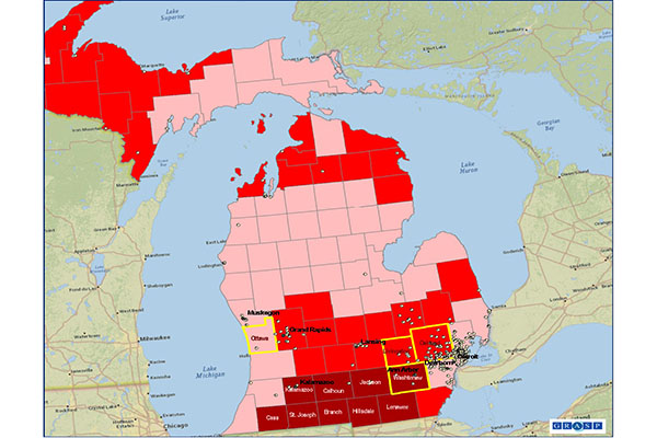
GIS can be a valuable tool for analyzing spatial elements and generating visual representations of data. ATSDR’s GRASP analysts can work with health assessors to create GIS maps with multiple layers depicting information, such as locations of contamination sources, areas of different concentrations of environmental contamination (e.g., plumes), population densities and other relevant demographic characteristics, and exposure points. These data can be shown for large areas, such as counties or large cities, and smaller locations, such as census tracts or blocks. Consult with GRASP specialists to determine if generating maps (see example GRASP maps) for site-specific applications is appropriate and feasible.
Determining Community Use Patterns Associated with Common Types of Media
| Medium | Ways to Identify Community Land and Natural Resource Use |
|---|---|
Groundwater |
|
Surface Water |
|

Fish, Shellfish, and Game |
|

Homegrown or Locally Obtained Foods |
|
Site Accessibility
People can come in contact with on-site contamination if access to the site is not restricted or otherwise limited. Do the following to determine if the community can access the contaminated site:
- Look for the presence of physical controls and barriers such as fences and gates. Check the condition and the extent of area protected by existing physical barriers. Keep in mind though that the presence of a physical control or barrier is not always a sufficient indication that the site is inaccessible.
- Check if institutional controls (e.g., deed restrictions, building permits) are in place to limit or prevent exposure. A review of local ordinances may reveal actions that have been taken to minimize exposure, such as prohibiting the construction of private wells in areas where contaminated groundwater is present. Just because institutional controls are on record does not necessarily assure their obedience or effectiveness at preventing exposure. At the same time, it is also possible for such actions to have taken place without being properly communicated or recorded.
- Look for evidence of trespassers. Example indicators of trespassing include footprints, garbage, vandalism (e.g., a spray-painted building), abandoned items (e.g., clothing), tire tracks, broken locks on gates, and openings in a fence.
- Identify abandoned buildings, standing water, hills, or streams that might attract children looking for a place to play.
- Identify the locations of contaminated materials (e.g., barrels, stained soils) within the site and the zones of contamination to determine how accessible they are to people.
- Find out if people are following directions on any posted signs at the site (e.g., fishing advisories, no trespassing signs).
Climatic Conditions
Evaluate all potential climatic conditions to gain valuable information on the general types and frequency of outdoor and recreational activities the local population engages in, and to assess the possibility of increased exposures resulting from weather-dependent factors. For example, during subfreezing and other inclement weather conditions (e.g., frozen ground, frozen precipitation), people may spend less time outside, thereby decreasing the frequency of their contact with outdoor contaminated media, yet at the same time, possibly increasing their exposure to indoor contaminated media (e.g., soil gas vapors in a basement play area, lead-based paint). Another example is the potential for increased dermal exposure to outdoor contaminated media during hot weather because some people tend to wear clothing with less skin coverage (e.g., shorts rather than long pants).
Estimating Numbers of People in Potentially Exposed Populations
Health assessors need to be very specific in defining who has been, is, or could be exposed to site contamination. For example, make sure to document the following features of the exposed or potentially exposed population:
- Specific age intervals (e.g., birth to <1 year, 2 to <6 years).
- Existence of vulnerable populations, such as pregnant and lactating women and the elderly.
- Presence of special groups such as recreational populations.
You will need to estimate the number of potentially exposed people for every completed and potential exposure pathway. This analysis will vary from site to site. Your efforts can range from running queries on U.S. Census data to estimate the number of people residing within a specified distance of a site, to performing more sophisticated analyses using GIS tools. For instance, if you need to know how many children live in a site area, you could break out the age groups of interest on a map. While mapping tools such as geocoding can help health assessors see the locations of specific addresses or households for potentially affected populations, such as those on a municipal water supply or users of private wells, ATSDR does not release any personally identifiable information (PII) because of privacy issues. For many sites, having ATSDR’s GRASP generate a map depicting demographics for a specified geographic area (e.g., within a certain radius of a site) is sufficient. Note that while health assessors can summarize information from the 1-mile radius demographic maps that GRASP generates, it is preferable to use sources (see text box) that help more precisely estimate the number of people exposed in completed and potential pathways.
Conducting Population Counts
You can quantify the number of potentially exposed people by conducting actual population counts or estimating the number of people residing in or frequenting an area. In general, when developing any count or estimate, take the following steps for each completed and potential exposure pathway:
- Review all available sampling data to determine the extent of the geographic area.
- Review site visit information to identify areas of greatest exposure potential (e.g., a subdivision located directly downgradient of a site).
- Estimate the number of people exposed or potentially exposed. For example, if you identified groundwater as a completed exposure pathway, identify groundwater use and determine the number of people using municipal water or the number of people using private wells that are contaminated or likely to be contaminated.
Remember that estimating the number of people who are likely to come in contact with a contaminated medium requires both a consideration of distance and access to the contamination. For instance, the likelihood and number of people accessing an unrestricted area with soil contamination would be clearly greater if the area borders a residential area rather than if it were separated by a four-lane highway or a heavily forested area.
ATSDR has developed a system called a Site Impact Assessment (SIA), which health assessors will use to document critical demographic information for each individual exposure pathway associated with a site including:
- Number of people assessed.
- Number of people with exposures that may increase the potential for health effects.
- Number of people with potential exposures that could increase the potential for health effects.
Sources for Estimating Potentially Exposed Populations
The U.S. Census is one of the most commonly used data sources for estimating potentially exposed populations, and ATSDR’s GRASP specialists are highly skilled at conducting spatial evaluations of Census data. However, at some sites, you might face challenges in quantifying populations, such as at sites with large transient populations. Other resources can help you get an accurate count:
- Neighborhood associations and local residents
- Representatives of municipal, county, and city agencies such as planners, managers, engineers, school officials, and health officials
- Individuals at federal, state, and tribal agencies such as EPA, park departments, departments of natural resources, geologic surveys, and environmental and health agencies
- Personnel departments
- Surveys
Learn about common types of demographic data to collect.
Learn what types of community information [PDF – 270 KB] you need to collect.